You are here: Home > Network List > TA - USArray Transportable Network (new EarthScope stations) Stations List
> Station N25K Chitina, Valdez-Cordova, AK, USA > Earthquake Result Viewer
N25K Chitina, Valdez-Cordova, AK, USA - Earthquake Result Viewer
| Earthquake location: |
Vanuatu Islands |
| Earthquake latitude/longitude: |
-16.4/168.1 |
| Earthquake time(UTC): |
2015/02/19 (050) 13:18:32 GMT |
| Earthquake Depth: |
10 km |
| Earthquake Magnitude: |
6.5 MWP |
| Earthquake Catalog/Contributor: |
NEIC PDE/NEIC COMCAT |
|
| Network: |
TA USArray Transportable Network (new EarthScope stations) |
| Station: |
N25K Chitina, Valdez-Cordova, AK, USA |
| Lat/Lon: |
61.61 N/144.60 W |
| Elevation: |
1087 m |
|
| Distance: |
86.3 deg |
| Az: |
20.616 deg |
| Baz: |
224.993 deg |
| Ray Param: |
0.04415223 |
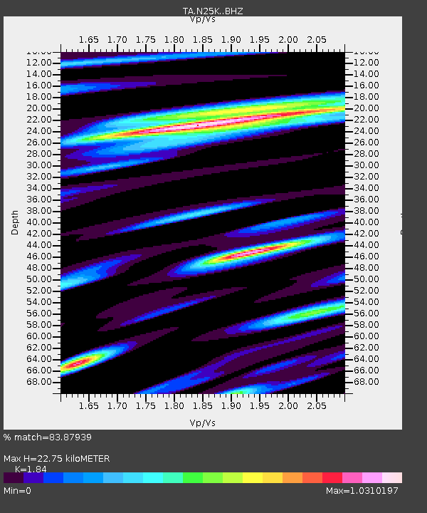
| Estimated Moho Depth: |
22.75 km |
| Estimated Crust Vp/Vs: |
1.84 |
| Assumed Crust Vp: |
6.566 km/s |
| Estimated Crust Vs: |
3.569 km/s |
| Estimated Crust Poisson's Ratio: |
0.29 |
|
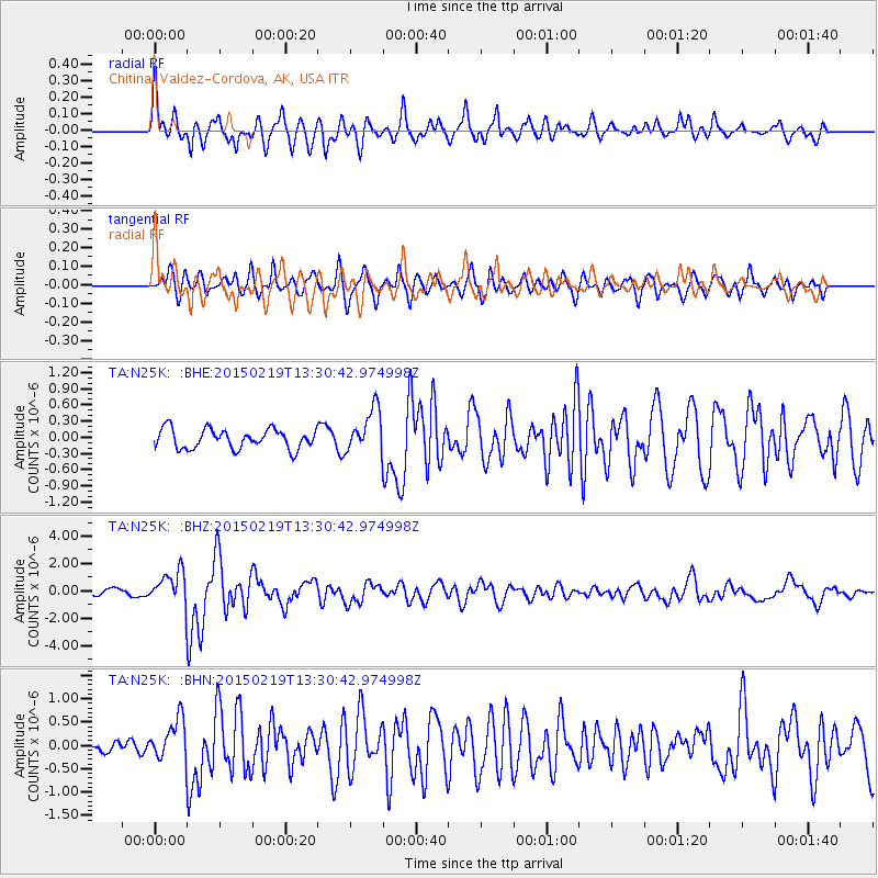
| Radial Match: |
83.87939 % |
| Radial Bump: |
400 |
| Transverse Match: |
76.02606 % |
| Transverse Bump: |
400 |
| SOD ConfigId: |
7019011 |
| Insert Time: |
2019-04-16 22:52:21.340 +0000 |
| GWidth: |
2.5 |
| Max Bumps: |
400 |
| Tol: |
0.001 |
|
Signal To Noise
| Channel | StoN | STA | LTA |
| TA:N25K: :BHZ:20150219T13:30:42.974998Z | 5.7011037 | 1.2351102E-6 | 2.1664405E-7 |
| TA:N25K: :BHN:20150219T13:30:42.974998Z | 4.8940177 | 4.5003267E-7 | 9.195567E-8 |
| TA:N25K: :BHE:20150219T13:30:42.974998Z | 2.2494187 | 4.0424797E-7 | 1.7971219E-7 |
| Arrivals |
| Ps | 3.0 SECOND |
| PpPs | 9.6 SECOND |
| PsPs/PpSs | 13 SECOND |


