You are here: Home > Network List > TA - USArray Transportable Network (new EarthScope stations) Stations List
> Station O03E Paynes Creek, CA, USA > Earthquake Result Viewer
O03E Paynes Creek, CA, USA - Earthquake Result Viewer
| Earthquake location: |
Vanuatu Islands |
| Earthquake latitude/longitude: |
-16.4/168.1 |
| Earthquake time(UTC): |
2015/02/19 (050) 13:18:32 GMT |
| Earthquake Depth: |
10 km |
| Earthquake Magnitude: |
6.5 MWP |
| Earthquake Catalog/Contributor: |
NEIC PDE/NEIC COMCAT |
|
| Network: |
TA USArray Transportable Network (new EarthScope stations) |
| Station: |
O03E Paynes Creek, CA, USA |
| Lat/Lon: |
40.29 N/121.80 W |
| Elevation: |
967 m |
|
| Distance: |
86.0 deg |
| Az: |
46.134 deg |
| Baz: |
244.786 deg |
| Ray Param: |
0.044332214 |
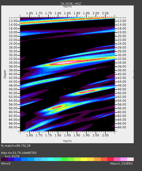
| Estimated Moho Depth: |
33.75 km |
| Estimated Crust Vp/Vs: |
1.84 |
| Assumed Crust Vp: |
6.566 km/s |
| Estimated Crust Vs: |
3.573 km/s |
| Estimated Crust Poisson's Ratio: |
0.29 |
|
| Radial Match: |
89.75129 % |
| Radial Bump: |
400 |
| Transverse Match: |
88.30395 % |
| Transverse Bump: |
334 |
| SOD ConfigId: |
7019011 |
| Insert Time: |
2019-04-16 22:52:23.344 +0000 |
| GWidth: |
2.5 |
| Max Bumps: |
400 |
| Tol: |
0.001 |
|
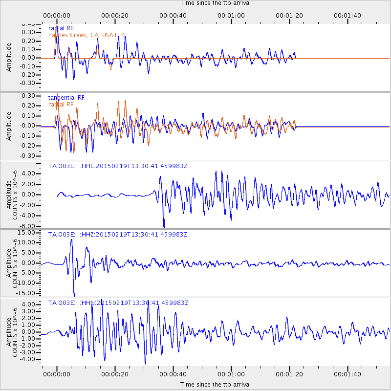
Signal To Noise
| Channel | StoN | STA | LTA |
| TA:O03E: :HHZ:20150219T13:30:41.459983Z | 11.014905 | 3.2956489E-6 | 2.9919903E-7 |
| TA:O03E: :HHN:20150219T13:30:41.459983Z | 1.6232247 | 3.7551732E-7 | 2.3134031E-7 |
| TA:O03E: :HHE:20150219T13:30:41.459983Z | 2.503964 | 5.245418E-7 | 2.0948457E-7 |
| Arrivals |
| Ps | 4.4 SECOND |
| PpPs | 14 SECOND |
| PsPs/PpSs | 19 SECOND |


