You are here: Home > Network List > II - Global Seismograph Network (GSN - IRIS/IDA) Stations List
> Station PFO Pinon Flat, California, USA > Earthquake Result Viewer
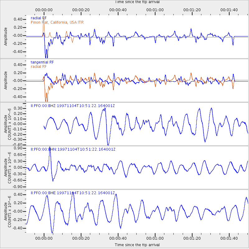
PFO Pinon Flat, California, USA - Earthquake Result Viewer
*The percent match for this event was below the threshold and hence no stack was calculated.
| Earthquake location: |
Fiji Islands Region |
| Earthquake latitude/longitude: |
-21.0/-179.2 |
| Earthquake time(UTC): |
1997/11/04 (308) 10:40:43 GMT |
| Earthquake Depth: |
621 km |
| Earthquake Magnitude: |
5.7 UNKNOWN, 5.1 MB |
| Earthquake Catalog/Contributor: |
WHDF/NEIC |
|
| Network: |
II Global Seismograph Network (GSN - IRIS/IDA) |
| Station: |
PFO Pinon Flat, California, USA |
| Lat/Lon: |
33.61 N/116.46 W |
| Elevation: |
1280 m |
|
| Distance: |
80.8 deg |
| Az: |
48.733 deg |
| Baz: |
237.289 deg |
| Ray Param: |
$rayparam |
*The percent match for this event was below the threshold and hence was not used in the summary stack. |
|
| Radial Match: |
66.163246 % |
| Radial Bump: |
400 |
| Transverse Match: |
44.50644 % |
| Transverse Bump: |
393 |
| SOD ConfigId: |
4480 |
| Insert Time: |
2010-03-01 21:47:09.734 +0000 |
| GWidth: |
2.5 |
| Max Bumps: |
400 |
| Tol: |
0.001 |
|
Signal To Noise
| Channel | StoN | STA | LTA |
| II:PFO:00:BHN:19971104T10:51:22.164001Z | 2.4070015 | 3.833504E-7 | 1.5926472E-7 |
| II:PFO:00:BHE:19971104T10:51:22.164001Z | 1.6949909 | 2.9325832E-7 | 1.730147E-7 |
| II:PFO:00:BHZ:19971104T10:51:22.164001Z | 2.7000165 | 2.34685E-7 | 8.691985E-8 |
| Arrivals |
| Ps | |
| PpPs | |
| PsPs/PpSs | |


