You are here: Home > Network List > UW - Pacific Northwest Regional Seismic Network Stations List
> Station MRBL Marblemount, WA, USA > Earthquake Result Viewer
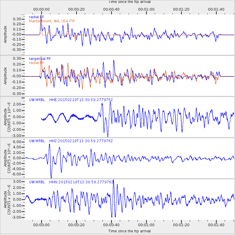
MRBL Marblemount, WA, USA - Earthquake Result Viewer
*The percent match for this event was below the threshold and hence no stack was calculated.
| Earthquake location: |
Vanuatu Islands |
| Earthquake latitude/longitude: |
-16.4/168.1 |
| Earthquake time(UTC): |
2015/02/19 (050) 13:18:32 GMT |
| Earthquake Depth: |
10 km |
| Earthquake Magnitude: |
6.5 MWP |
| Earthquake Catalog/Contributor: |
NEIC PDE/NEIC COMCAT |
|
| Network: |
UW Pacific Northwest Regional Seismic Network |
| Station: |
MRBL Marblemount, WA, USA |
| Lat/Lon: |
48.52 N/121.48 W |
| Elevation: |
75 m |
|
| Distance: |
89.8 deg |
| Az: |
38.79 deg |
| Baz: |
244.738 deg |
| Ray Param: |
$rayparam |
*The percent match for this event was below the threshold and hence was not used in the summary stack. |
|
| Radial Match: |
75.84013 % |
| Radial Bump: |
400 |
| Transverse Match: |
76.674545 % |
| Transverse Bump: |
400 |
| SOD ConfigId: |
7019011 |
| Insert Time: |
2019-04-16 22:53:31.181 +0000 |
| GWidth: |
2.5 |
| Max Bumps: |
400 |
| Tol: |
0.001 |
|
Signal To Noise
| Channel | StoN | STA | LTA |
| UW:MRBL: :HHZ:20150219T13:30:59.277976Z | 5.2176766 | 1.8689911E-6 | 3.5820372E-7 |
| UW:MRBL: :HHN:20150219T13:30:59.277976Z | 0.885113 | 3.2912075E-7 | 3.7184037E-7 |
| UW:MRBL: :HHE:20150219T13:30:59.277976Z | 2.355424 | 8.8619475E-7 | 3.7623576E-7 |
| Arrivals |
| Ps | |
| PpPs | |
| PsPs/PpSs | |


