You are here: Home > Network List > II - Global Seismograph Network (GSN - IRIS/IDA) Stations List
> Station PFO Pinon Flat, California, USA > Earthquake Result Viewer
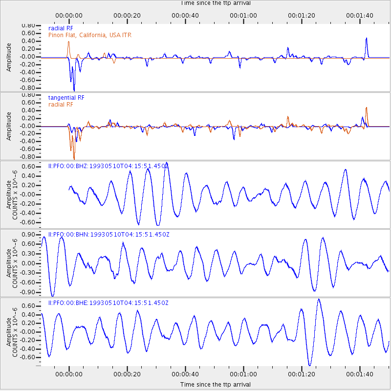
PFO Pinon Flat, California, USA - Earthquake Result Viewer
*The percent match for this event was below the threshold and hence no stack was calculated.
| Earthquake location: |
Southern East Pacific Rise |
| Earthquake latitude/longitude: |
-53.0/-118.0 |
| Earthquake time(UTC): |
1993/05/10 (130) 04:03:41 GMT |
| Earthquake Depth: |
10 km |
| Earthquake Magnitude: |
5.6 MS, 5.1 MB |
| Earthquake Catalog/Contributor: |
WHDF/NEIC |
|
| Network: |
II Global Seismograph Network (GSN - IRIS/IDA) |
| Station: |
PFO Pinon Flat, California, USA |
| Lat/Lon: |
33.61 N/116.46 W |
| Elevation: |
1280 m |
|
| Distance: |
86.3 deg |
| Az: |
1.313 deg |
| Baz: |
180.951 deg |
| Ray Param: |
$rayparam |
*The percent match for this event was below the threshold and hence was not used in the summary stack. |
|
| Radial Match: |
85.53088 % |
| Radial Bump: |
400 |
| Transverse Match: |
58.540077 % |
| Transverse Bump: |
326 |
| SOD ConfigId: |
4480 |
| Insert Time: |
2010-03-01 21:47:13.315 +0000 |
| GWidth: |
2.5 |
| Max Bumps: |
400 |
| Tol: |
0.001 |
|
Signal To Noise
| Channel | StoN | STA | LTA |
| II:PFO:00:BHN:19930510T04:15:51.450Z | 0.9739012 | 3.6485721E-7 | 3.746347E-7 |
| II:PFO:00:BHE:19930510T04:15:51.450Z | 0.86246365 | 2.039703E-7 | 2.3649727E-7 |
| II:PFO:00:BHZ:19930510T04:15:51.450Z | 2.1003845 | 5.017743E-7 | 2.388964E-7 |
| Arrivals |
| Ps | |
| PpPs | |
| PsPs/PpSs | |


