You are here: Home > Network List > XD14 - Illuminating the architecture of the greater Mount St. Helens magmatic systems f Stations List
> Station MJ02 "Mount St Helens, WA" > Earthquake Result Viewer
MJ02 "Mount St Helens, WA" - Earthquake Result Viewer
| Earthquake location: |
Vanuatu Islands |
| Earthquake latitude/longitude: |
-16.4/168.1 |
| Earthquake time(UTC): |
2015/02/19 (050) 13:18:32 GMT |
| Earthquake Depth: |
10 km |
| Earthquake Magnitude: |
6.5 MWP |
| Earthquake Catalog/Contributor: |
NEIC PDE/NEIC COMCAT |
|
| Network: |
XD Illuminating the architecture of the greater Mount St. Helens magmatic systems f |
| Station: |
MJ02 "Mount St Helens, WA" |
| Lat/Lon: |
46.14 N/122.70 W |
| Elevation: |
317 m |
|
| Distance: |
88.0 deg |
| Az: |
40.576 deg |
| Baz: |
243.882 deg |
| Ray Param: |
0.04292557 |
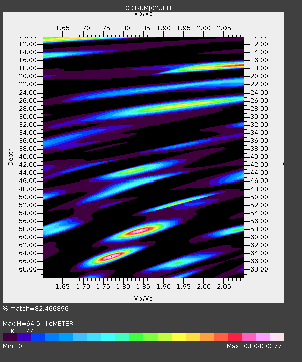
| Estimated Moho Depth: |
64.5 km |
| Estimated Crust Vp/Vs: |
1.77 |
| Assumed Crust Vp: |
6.566 km/s |
| Estimated Crust Vs: |
3.71 km/s |
| Estimated Crust Poisson's Ratio: |
0.27 |
|
| Radial Match: |
82.466896 % |
| Radial Bump: |
400 |
| Transverse Match: |
85.44315 % |
| Transverse Bump: |
373 |
| SOD ConfigId: |
7019011 |
| Insert Time: |
2019-04-16 22:54:18.832 +0000 |
| GWidth: |
2.5 |
| Max Bumps: |
400 |
| Tol: |
0.001 |
|

Signal To Noise
| Channel | StoN | STA | LTA |
| XD:MJ02: :BHZ:20150219T13:30:50.90499Z | 8.653541 | 1.5483262E-6 | 1.7892401E-7 |
| XD:MJ02: :BHN:20150219T13:30:50.90499Z | 1.1457139 | 3.0897763E-7 | 2.696813E-7 |
| XD:MJ02: :BHE:20150219T13:30:50.90499Z | 1.827647 | 2.992091E-7 | 1.6371274E-7 |
| Arrivals |
| Ps | 7.7 SECOND |
| PpPs | 27 SECOND |
| PsPs/PpSs | 34 SECOND |


