You are here: Home > Network List > XD14 - Illuminating the architecture of the greater Mount St. Helens magmatic systems f Stations List
> Station MN07 "Mount St Helens, WA" > Earthquake Result Viewer
MN07 "Mount St Helens, WA" - Earthquake Result Viewer
| Earthquake location: |
Vanuatu Islands |
| Earthquake latitude/longitude: |
-16.4/168.1 |
| Earthquake time(UTC): |
2015/02/19 (050) 13:18:32 GMT |
| Earthquake Depth: |
10 km |
| Earthquake Magnitude: |
6.5 MWP |
| Earthquake Catalog/Contributor: |
NEIC PDE/NEIC COMCAT |
|
| Network: |
XD Illuminating the architecture of the greater Mount St. Helens magmatic systems f |
| Station: |
MN07 "Mount St Helens, WA" |
| Lat/Lon: |
45.99 N/122.08 W |
| Elevation: |
861 m |
|
| Distance: |
88.3 deg |
| Az: |
40.896 deg |
| Baz: |
244.337 deg |
| Ray Param: |
0.04268456 |
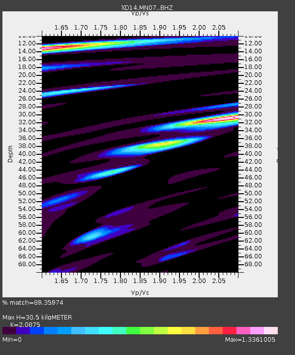
| Estimated Moho Depth: |
30.5 km |
| Estimated Crust Vp/Vs: |
2.09 |
| Assumed Crust Vp: |
6.566 km/s |
| Estimated Crust Vs: |
3.145 km/s |
| Estimated Crust Poisson's Ratio: |
0.35 |
|
| Radial Match: |
89.35974 % |
| Radial Bump: |
334 |
| Transverse Match: |
79.47226 % |
| Transverse Bump: |
354 |
| SOD ConfigId: |
7019011 |
| Insert Time: |
2019-04-16 22:54:34.436 +0000 |
| GWidth: |
2.5 |
| Max Bumps: |
400 |
| Tol: |
0.001 |
|

Signal To Noise
| Channel | StoN | STA | LTA |
| XD:MN07: :BHZ:20150219T13:30:52.449973Z | 8.237694 | 2.0683622E-6 | 2.510851E-7 |
| XD:MN07: :BHN:20150219T13:30:52.449973Z | 1.5928022 | 5.367702E-7 | 3.3699737E-7 |
| XD:MN07: :BHE:20150219T13:30:52.449973Z | 2.1028748 | 6.549846E-7 | 3.1147104E-7 |
| Arrivals |
| Ps | 5.1 SECOND |
| PpPs | 14 SECOND |
| PsPs/PpSs | 19 SECOND |


