You are here: Home > Network List > CI - Caltech Regional Seismic Network Stations List
> Station VCS Vincent Substation, Palmdale, CA, USA > Earthquake Result Viewer
VCS Vincent Substation, Palmdale, CA, USA - Earthquake Result Viewer
| Earthquake location: |
Vanuatu Islands |
| Earthquake latitude/longitude: |
-15.4/166.9 |
| Earthquake time(UTC): |
2000/10/04 (278) 16:58:44 GMT |
| Earthquake Depth: |
23 km |
| Earthquake Magnitude: |
6.1 MB, 6.9 MS, 6.8 MW, 6.5 ME |
| Earthquake Catalog/Contributor: |
WHDF/NEIC |
|
| Network: |
CI Caltech Regional Seismic Network |
| Station: |
VCS Vincent Substation, Palmdale, CA, USA |
| Lat/Lon: |
34.48 N/118.12 W |
| Elevation: |
991 m |
|
| Distance: |
86.7 deg |
| Az: |
53.047 deg |
| Baz: |
248.911 deg |
| Ray Param: |
0.04384115 |
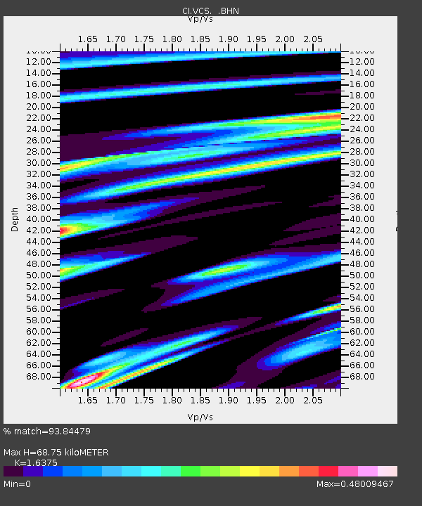
| Estimated Moho Depth: |
68.75 km |
| Estimated Crust Vp/Vs: |
1.64 |
| Assumed Crust Vp: |
6.1 km/s |
| Estimated Crust Vs: |
3.725 km/s |
| Estimated Crust Poisson's Ratio: |
0.20 |
|
| Radial Match: |
93.84479 % |
| Radial Bump: |
400 |
| Transverse Match: |
73.58625 % |
| Transverse Bump: |
400 |
| SOD ConfigId: |
3787 |
| Insert Time: |
2010-02-25 21:03:31.156 +0000 |
| GWidth: |
2.5 |
| Max Bumps: |
400 |
| Tol: |
0.001 |
|
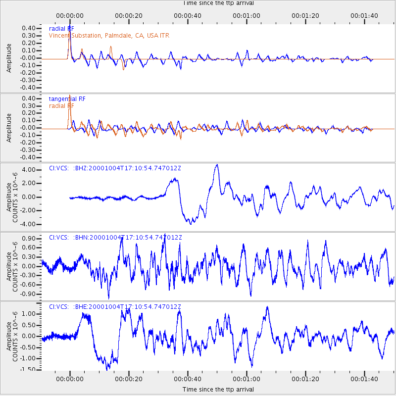
Signal To Noise
| Channel | StoN | STA | LTA |
| CI:VCS: :BHN:20001004T17:10:54.747012Z | 1.3360004 | 2.0234134E-7 | 1.5145305E-7 |
| CI:VCS: :BHE:20001004T17:10:54.747012Z | 4.7582393 | 4.867391E-7 | 1.0229396E-7 |
| CI:VCS: :BHZ:20001004T17:10:54.747012Z | 8.543236 | 1.2726595E-6 | 1.4896692E-7 |
| Arrivals |
| Ps | 7.3 SECOND |
| PpPs | 29 SECOND |
| PsPs/PpSs | 36 SECOND |


