You are here: Home > Network List > II - Global Seismograph Network (GSN - IRIS/IDA) Stations List
> Station PFO Pinon Flat, California, USA > Earthquake Result Viewer
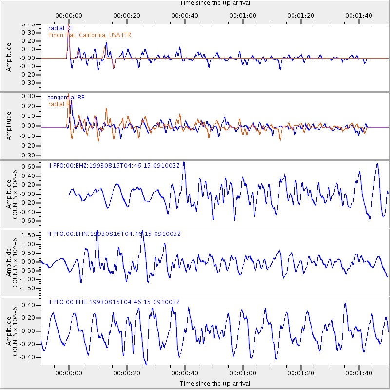
PFO Pinon Flat, California, USA - Earthquake Result Viewer
*The percent match for this event was below the threshold and hence no stack was calculated.
| Earthquake location: |
South Of Mariana Islands |
| Earthquake latitude/longitude: |
13.0/144.9 |
| Earthquake time(UTC): |
1993/08/16 (228) 04:33:50 GMT |
| Earthquake Depth: |
33 km |
| Earthquake Magnitude: |
5.8 MB, 6.0 MS, 6.0 UNKNOWN, 6.2 MW |
| Earthquake Catalog/Contributor: |
WHDF/NEIC |
|
| Network: |
II Global Seismograph Network (GSN - IRIS/IDA) |
| Station: |
PFO Pinon Flat, California, USA |
| Lat/Lon: |
33.61 N/116.46 W |
| Elevation: |
1280 m |
|
| Distance: |
89.9 deg |
| Az: |
55.605 deg |
| Baz: |
285.436 deg |
| Ray Param: |
$rayparam |
*The percent match for this event was below the threshold and hence was not used in the summary stack. |
|
| Radial Match: |
82.93548 % |
| Radial Bump: |
400 |
| Transverse Match: |
65.22897 % |
| Transverse Bump: |
400 |
| SOD ConfigId: |
4480 |
| Insert Time: |
2010-03-01 21:47:52.991 +0000 |
| GWidth: |
2.5 |
| Max Bumps: |
400 |
| Tol: |
0.001 |
|
Signal To Noise
| Channel | StoN | STA | LTA |
| II:PFO:00:BHN:19930816T04:46:15.091003Z | 2.823013 | 4.503269E-7 | 1.5951994E-7 |
| II:PFO:00:BHE:19930816T04:46:15.091003Z | 1.0811577 | 1.4849486E-7 | 1.3734801E-7 |
| II:PFO:00:BHZ:19930816T04:46:15.091003Z | 1.3891221 | 1.8492436E-7 | 1.3312318E-7 |
| Arrivals |
| Ps | |
| PpPs | |
| PsPs/PpSs | |


