You are here: Home > Network List > II - Global Seismograph Network (GSN - IRIS/IDA) Stations List
> Station PFO Pinon Flat, California, USA > Earthquake Result Viewer
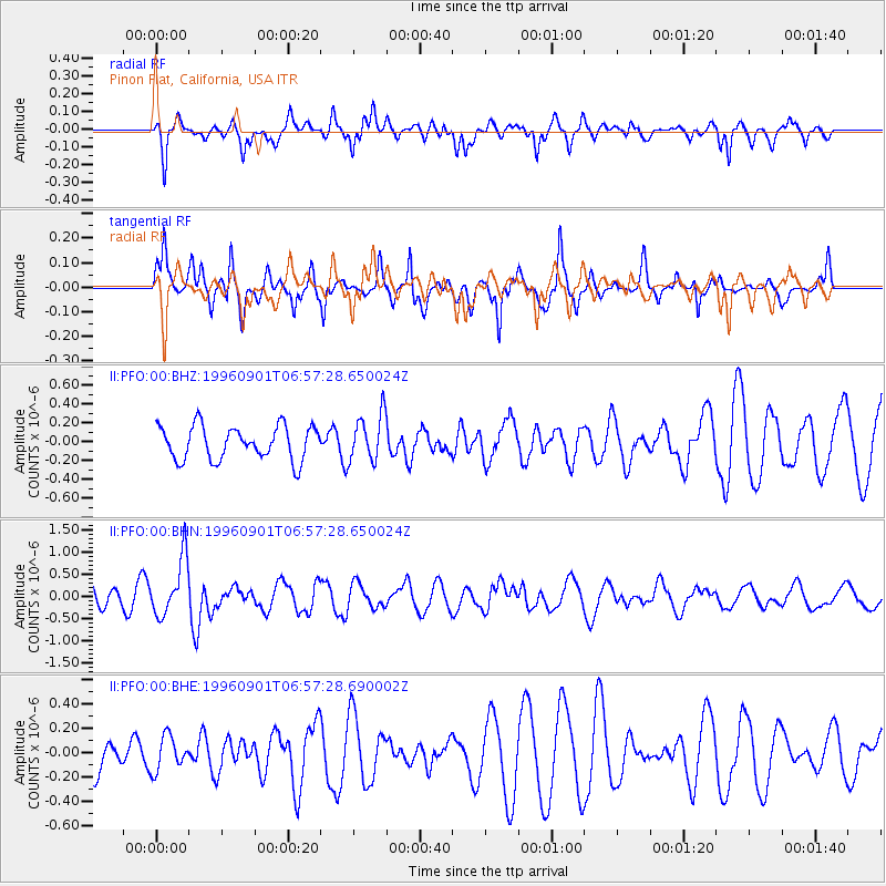
PFO Pinon Flat, California, USA - Earthquake Result Viewer
*The percent match for this event was below the threshold and hence no stack was calculated.
| Earthquake location: |
Santa Cruz Islands |
| Earthquake latitude/longitude: |
-11.8/166.6 |
| Earthquake time(UTC): |
1996/09/01 (245) 06:45:41 GMT |
| Earthquake Depth: |
187 km |
| Earthquake Magnitude: |
5.5 MB, 5.9 UNKNOWN, 5.8 MW |
| Earthquake Catalog/Contributor: |
WHDF/NEIC |
|
| Network: |
II Global Seismograph Network (GSN - IRIS/IDA) |
| Station: |
PFO Pinon Flat, California, USA |
| Lat/Lon: |
33.61 N/116.46 W |
| Elevation: |
1280 m |
|
| Distance: |
85.8 deg |
| Az: |
54.594 deg |
| Baz: |
252.991 deg |
| Ray Param: |
$rayparam |
*The percent match for this event was below the threshold and hence was not used in the summary stack. |
|
| Radial Match: |
66.234474 % |
| Radial Bump: |
381 |
| Transverse Match: |
83.83905 % |
| Transverse Bump: |
370 |
| SOD ConfigId: |
4480 |
| Insert Time: |
2010-03-01 21:48:01.814 +0000 |
| GWidth: |
2.5 |
| Max Bumps: |
400 |
| Tol: |
0.001 |
|
Signal To Noise
| Channel | StoN | STA | LTA |
| II:PFO:00:BHN:19960901T06:57:28.650024Z | 1.8797605 | 6.417515E-7 | 3.4140066E-7 |
| II:PFO:00:BHE:19960901T06:57:28.690002Z | 0.6000613 | 1.3917898E-7 | 2.3194126E-7 |
| II:PFO:00:BHZ:19960901T06:57:28.650024Z | 1.403852 | 2.4813951E-7 | 1.7675617E-7 |
| Arrivals |
| Ps | |
| PpPs | |
| PsPs/PpSs | |


