You are here: Home > Network List > JP - Japan Meteorological Agency Seismic Network Stations List
> Station JKA Kamikawa Asahi > Earthquake Result Viewer
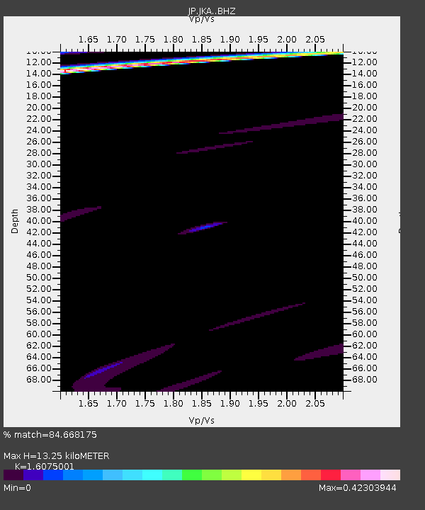
JKA Kamikawa Asahi - Earthquake Result Viewer
| Earthquake location: |
Vanuatu Islands |
| Earthquake latitude/longitude: |
-16.5/168.1 |
| Earthquake time(UTC): |
2015/02/19 (050) 13:38:32 GMT |
| Earthquake Depth: |
35 km |
| Earthquake Magnitude: |
4.9 mb |
| Earthquake Catalog/Contributor: |
ISC/ISC |
|
| Network: |
JP Japan Meteorological Agency Seismic Network |
| Station: |
JKA Kamikawa Asahi |
| Lat/Lon: |
41.12 N/142.59 E |
| Elevation: |
220 m |
|
| Distance: |
62.0 deg |
| Az: |
338.386 deg |
| Baz: |
152.111 deg |
| Ray Param: |
0.060455363 |
| Estimated Moho Depth: |
13.25 km |
| Estimated Crust Vp/Vs: |
1.61 |
| Assumed Crust Vp: |
6.183 km/s |
| Estimated Crust Vs: |
3.846 km/s |
| Estimated Crust Poisson's Ratio: |
0.18 |
|
| Radial Match: |
84.668175 % |
| Radial Bump: |
335 |
| Transverse Match: |
52.196503 % |
| Transverse Bump: |
400 |
| SOD ConfigId: |
7019011 |
| Insert Time: |
2019-04-16 22:59:52.372 +0000 |
| GWidth: |
2.5 |
| Max Bumps: |
400 |
| Tol: |
0.001 |
|

Signal To Noise
| Channel | StoN | STA | LTA |
| JP:JKA: :BHZ:20150219T13:48:35.950012Z | 1.8999625 | 1.944324E-6 | 1.0233485E-6 |
| JP:JKA: :BHN:20150219T13:48:35.950012Z | 14.481136 | 5.200236E-6 | 3.5910415E-7 |
| JP:JKA: :BHE:20150219T13:48:35.950012Z | 1.4544439 | 1.854753E-6 | 1.2752316E-6 |
| Arrivals |
| Ps | 1.4 SECOND |
| PpPs | 5.3 SECOND |
| PsPs/PpSs | 6.7 SECOND |


