You are here: Home > Network List > TA - USArray Transportable Network (new EarthScope stations) Stations List
> Station N49A Columbus Grove, OH, USA > Earthquake Result Viewer
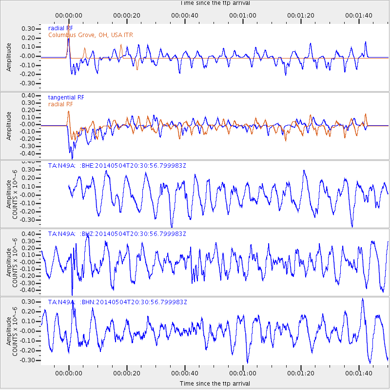
N49A Columbus Grove, OH, USA - Earthquake Result Viewer
*The percent match for this event was below the threshold and hence no stack was calculated.
| Earthquake location: |
Near S. Coast Of Honshu, Japan |
| Earthquake latitude/longitude: |
34.9/139.3 |
| Earthquake time(UTC): |
2014/05/04 (124) 20:18:25 GMT |
| Earthquake Depth: |
156 km |
| Earthquake Magnitude: |
5.8 MB |
| Earthquake Catalog/Contributor: |
NEIC PDE/NEIC COMCAT |
|
| Network: |
TA USArray Transportable Network (new EarthScope stations) |
| Station: |
N49A Columbus Grove, OH, USA |
| Lat/Lon: |
40.92 N/84.18 W |
| Elevation: |
225 m |
|
| Distance: |
94.6 deg |
| Az: |
31.554 deg |
| Baz: |
325.413 deg |
| Ray Param: |
$rayparam |
*The percent match for this event was below the threshold and hence was not used in the summary stack. |
|
| Radial Match: |
60.925385 % |
| Radial Bump: |
400 |
| Transverse Match: |
64.59614 % |
| Transverse Bump: |
400 |
| SOD ConfigId: |
626651 |
| Insert Time: |
2014-05-18 21:12:53.829 +0000 |
| GWidth: |
2.5 |
| Max Bumps: |
400 |
| Tol: |
0.001 |
|
Signal To Noise
| Channel | StoN | STA | LTA |
| TA:N49A: :BHZ:20140504T20:30:56.799983Z | 1.4592447 | 1.6675882E-7 | 1.1427748E-7 |
| TA:N49A: :BHN:20140504T20:30:56.799983Z | 0.9483319 | 1.5596831E-7 | 1.6446596E-7 |
| TA:N49A: :BHE:20140504T20:30:56.799983Z | 1.0789299 | 1.4788215E-7 | 1.3706372E-7 |
| Arrivals |
| Ps | |
| PpPs | |
| PsPs/PpSs | |


