You are here: Home > Network List > TA - USArray Transportable Network (new EarthScope stations) Stations List
> Station POKR Poker Plat Research Range, AK, USA > Earthquake Result Viewer
POKR Poker Plat Research Range, AK, USA - Earthquake Result Viewer
| Earthquake location: |
Near S. Coast Of Honshu, Japan |
| Earthquake latitude/longitude: |
34.9/139.3 |
| Earthquake time(UTC): |
2014/05/04 (124) 20:18:25 GMT |
| Earthquake Depth: |
156 km |
| Earthquake Magnitude: |
5.8 MB |
| Earthquake Catalog/Contributor: |
NEIC PDE/NEIC COMCAT |
|
| Network: |
TA USArray Transportable Network (new EarthScope stations) |
| Station: |
POKR Poker Plat Research Range, AK, USA |
| Lat/Lon: |
65.12 N/147.43 W |
| Elevation: |
501 m |
|
| Distance: |
52.0 deg |
| Az: |
30.959 deg |
| Baz: |
271.913 deg |
| Ray Param: |
0.06654237 |
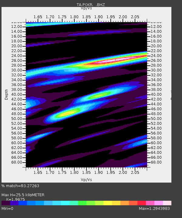
| Estimated Moho Depth: |
25.5 km |
| Estimated Crust Vp/Vs: |
1.97 |
| Assumed Crust Vp: |
6.566 km/s |
| Estimated Crust Vs: |
3.337 km/s |
| Estimated Crust Poisson's Ratio: |
0.33 |
|
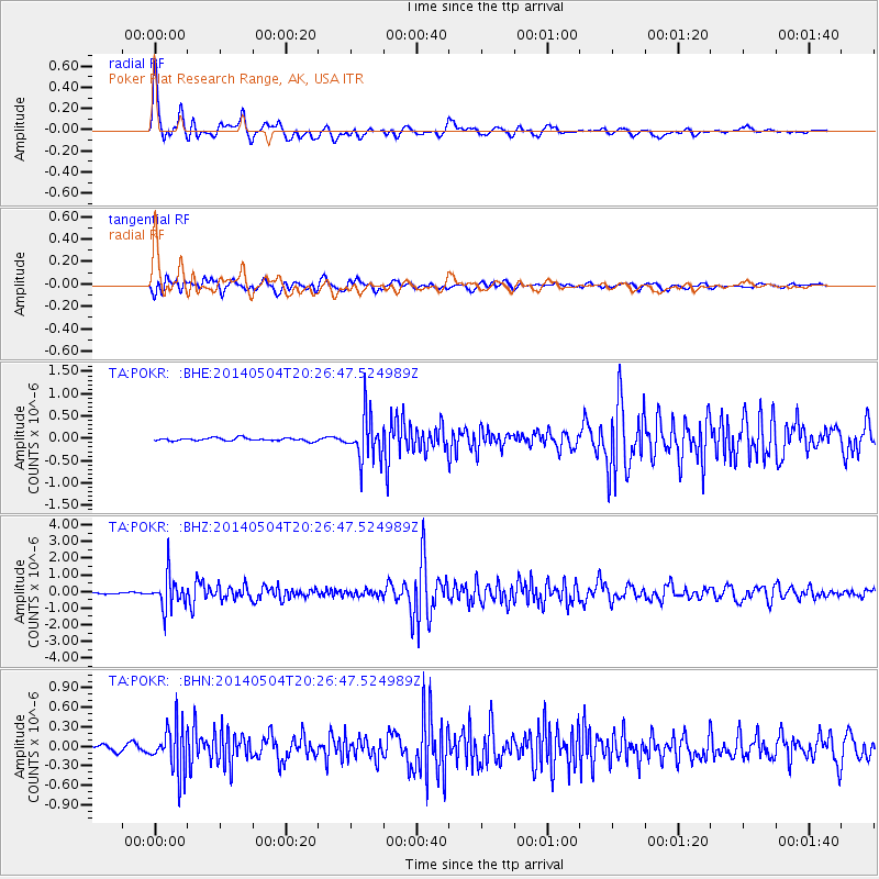
| Radial Match: |
93.27263 % |
| Radial Bump: |
400 |
| Transverse Match: |
74.075516 % |
| Transverse Bump: |
400 |
| SOD ConfigId: |
626651 |
| Insert Time: |
2014-05-18 21:13:28.636 +0000 |
| GWidth: |
2.5 |
| Max Bumps: |
400 |
| Tol: |
0.001 |
|
Signal To Noise
| Channel | StoN | STA | LTA |
| TA:POKR: :BHZ:20140504T20:26:47.524989Z | 15.463474 | 9.853406E-7 | 6.372052E-8 |
| TA:POKR: :BHN:20140504T20:26:47.524989Z | 5.7944865 | 3.502894E-7 | 6.0452194E-8 |
| TA:POKR: :BHE:20140504T20:26:47.524989Z | 14.675615 | 5.0251236E-7 | 3.4241314E-8 |
| Arrivals |
| Ps | 4.0 SECOND |
| PpPs | 11 SECOND |
| PsPs/PpSs | 15 SECOND |


