You are here: Home > Network List > II - Global Seismograph Network (GSN - IRIS/IDA) Stations List
> Station PFO Pinon Flat, California, USA > Earthquake Result Viewer
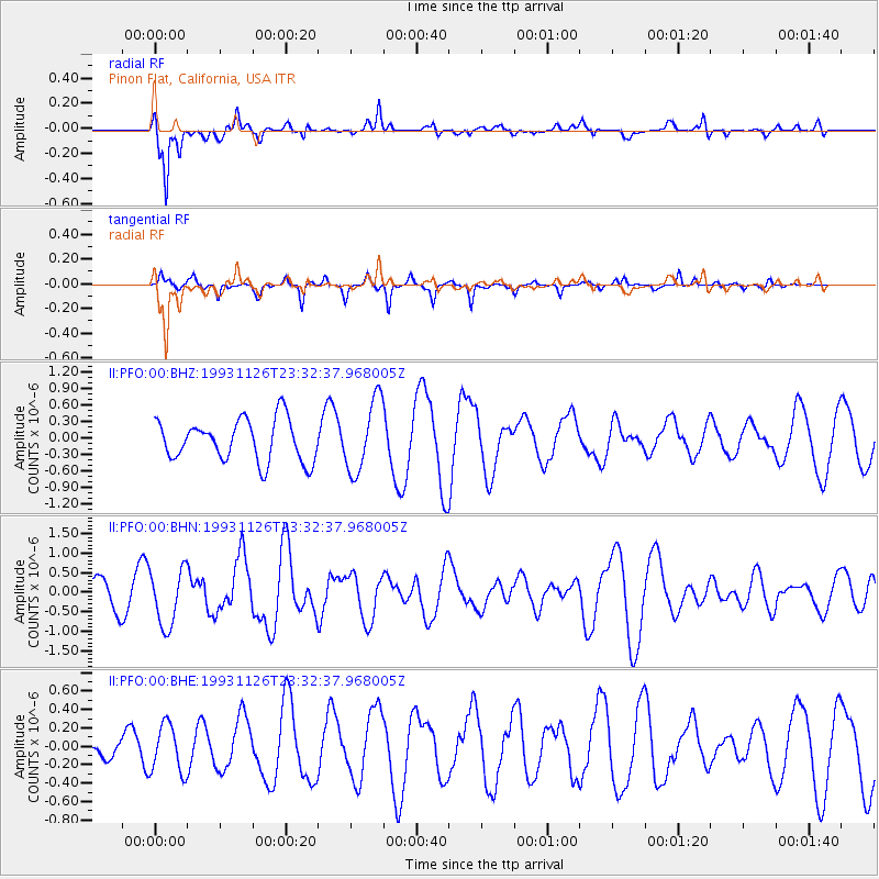
PFO Pinon Flat, California, USA - Earthquake Result Viewer
*The percent match for this event was below the threshold and hence no stack was calculated.
| Earthquake location: |
Solomon Islands |
| Earthquake latitude/longitude: |
-9.6/158.1 |
| Earthquake time(UTC): |
1993/11/26 (330) 23:20:05 GMT |
| Earthquake Depth: |
23 km |
| Earthquake Magnitude: |
5.8 MB, 6.2 MS, 6.1 UNKNOWN, 6.3 MW |
| Earthquake Catalog/Contributor: |
WHDF/NEIC |
|
| Network: |
II Global Seismograph Network (GSN - IRIS/IDA) |
| Station: |
PFO Pinon Flat, California, USA |
| Lat/Lon: |
33.61 N/116.46 W |
| Elevation: |
1280 m |
|
| Distance: |
91.4 deg |
| Az: |
56.317 deg |
| Baz: |
259.529 deg |
| Ray Param: |
$rayparam |
*The percent match for this event was below the threshold and hence was not used in the summary stack. |
|
| Radial Match: |
84.06189 % |
| Radial Bump: |
363 |
| Transverse Match: |
82.2321 % |
| Transverse Bump: |
246 |
| SOD ConfigId: |
4480 |
| Insert Time: |
2010-03-01 21:48:23.600 +0000 |
| GWidth: |
2.5 |
| Max Bumps: |
400 |
| Tol: |
0.001 |
|
Signal To Noise
| Channel | StoN | STA | LTA |
| II:PFO:00:BHN:19931126T23:32:37.968005Z | 1.9361179 | 7.251129E-7 | 3.7451898E-7 |
| II:PFO:00:BHE:19931126T23:32:37.968005Z | 2.5403073 | 2.613656E-7 | 1.02887405E-7 |
| II:PFO:00:BHZ:19931126T23:32:37.968005Z | 1.7556487 | 6.630558E-7 | 3.7766998E-7 |
| Arrivals |
| Ps | |
| PpPs | |
| PsPs/PpSs | |


