You are here: Home > Network List > II - Global Seismograph Network (GSN - IRIS/IDA) Stations List
> Station PFO Pinon Flat, California, USA > Earthquake Result Viewer
PFO Pinon Flat, California, USA - Earthquake Result Viewer
*The percent match for this event was below the threshold and hence no stack was calculated.
| Earthquake location: |
Kuril Islands |
| Earthquake latitude/longitude: |
50.8/157.4 |
| Earthquake time(UTC): |
1995/09/30 (273) 10:47:56 GMT |
| Earthquake Depth: |
33 km |
| Earthquake Magnitude: |
5.7 MB, 5.5 MS |
| Earthquake Catalog/Contributor: |
WHDF/NEIC |
|
| Network: |
II Global Seismograph Network (GSN - IRIS/IDA) |
| Station: |
PFO Pinon Flat, California, USA |
| Lat/Lon: |
33.61 N/116.46 W |
| Elevation: |
1280 m |
|
| Distance: |
62.5 deg |
| Az: |
69.803 deg |
| Baz: |
314.497 deg |
| Ray Param: |
$rayparam |
*The percent match for this event was below the threshold and hence was not used in the summary stack. |
|
| Radial Match: |
45.938927 % |
| Radial Bump: |
325 |
| Transverse Match: |
50.29473 % |
| Transverse Bump: |
322 |
| SOD ConfigId: |
4480 |
| Insert Time: |
2010-03-01 21:48:25.365 +0000 |
| GWidth: |
2.5 |
| Max Bumps: |
400 |
| Tol: |
0.001 |
|
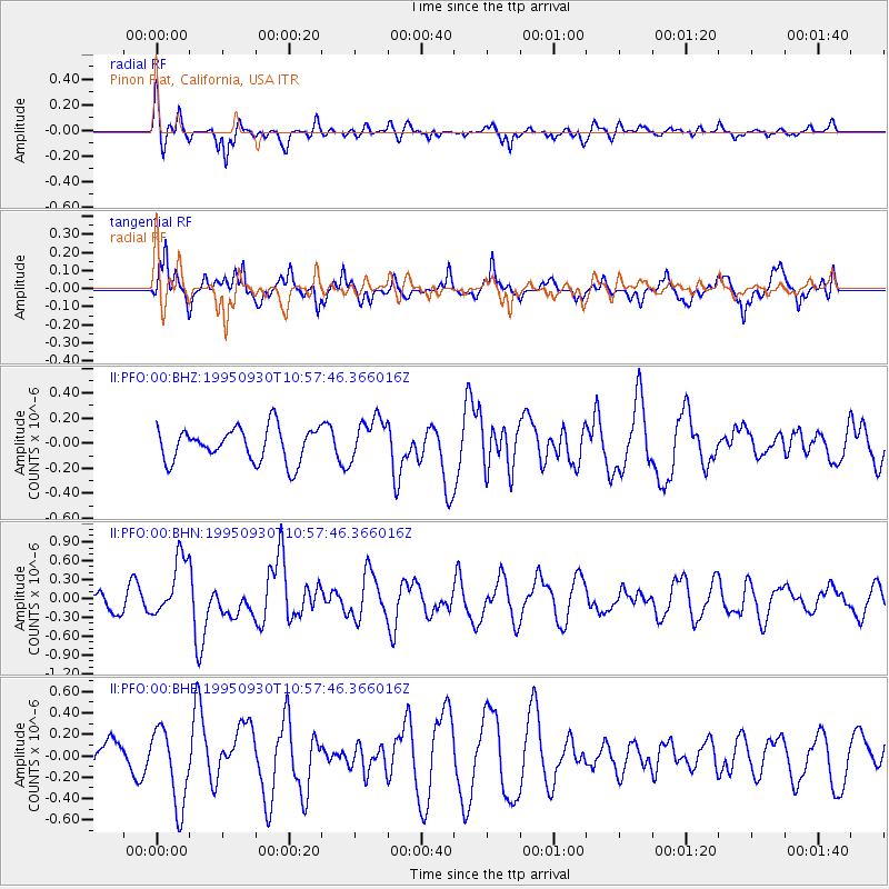
Signal To Noise
| Channel | StoN | STA | LTA |
| II:PFO:00:BHN:19950930T10:57:46.366016Z | 4.4253097 | 4.7624772E-7 | 1.07619066E-7 |
| II:PFO:00:BHE:19950930T10:57:46.366016Z | 1.4823664 | 3.648447E-7 | 2.4612316E-7 |
| II:PFO:00:BHZ:19950930T10:57:46.366016Z | 1.2778939 | 1.7198478E-7 | 1.3458455E-7 |
| Arrivals |
| Ps | |
| PpPs | |
| PsPs/PpSs | |


