You are here: Home > Network List > UW - Pacific Northwest Regional Seismic Network Stations List
> Station PASS Maple Falls, WA, USA > Earthquake Result Viewer
PASS Maple Falls, WA, USA - Earthquake Result Viewer
| Earthquake location: |
Near S. Coast Of Honshu, Japan |
| Earthquake latitude/longitude: |
34.9/139.3 |
| Earthquake time(UTC): |
2014/05/04 (124) 20:18:25 GMT |
| Earthquake Depth: |
156 km |
| Earthquake Magnitude: |
5.8 MB |
| Earthquake Catalog/Contributor: |
NEIC PDE/NEIC COMCAT |
|
| Network: |
UW Pacific Northwest Regional Seismic Network |
| Station: |
PASS Maple Falls, WA, USA |
| Lat/Lon: |
49.00 N/122.09 W |
| Elevation: |
174 m |
|
| Distance: |
69.7 deg |
| Az: |
43.987 deg |
| Baz: |
299.909 deg |
| Ray Param: |
0.0550756 |
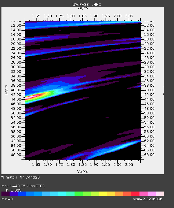
| Estimated Moho Depth: |
43.25 km |
| Estimated Crust Vp/Vs: |
1.61 |
| Assumed Crust Vp: |
6.566 km/s |
| Estimated Crust Vs: |
4.091 km/s |
| Estimated Crust Poisson's Ratio: |
0.18 |
|
| Radial Match: |
94.744026 % |
| Radial Bump: |
219 |
| Transverse Match: |
97.25905 % |
| Transverse Bump: |
153 |
| SOD ConfigId: |
626651 |
| Insert Time: |
2014-05-18 21:19:30.786 +0000 |
| GWidth: |
2.5 |
| Max Bumps: |
400 |
| Tol: |
0.001 |
|
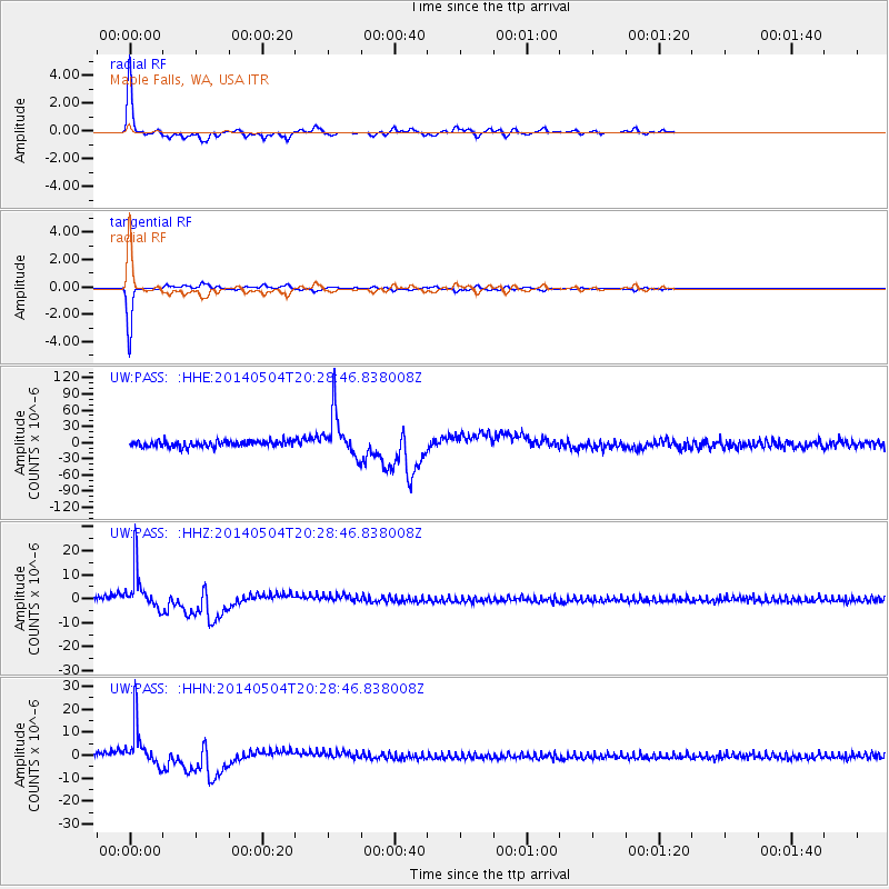
Signal To Noise
| Channel | StoN | STA | LTA |
| UW:PASS: :HHZ:20140504T20:28:46.838008Z | 7.7236786 | 8.513456E-6 | 1.1022541E-6 |
| UW:PASS: :HHN:20140504T20:28:46.838008Z | 7.727517 | 9.041925E-6 | 1.1700945E-6 |
| UW:PASS: :HHE:20140504T20:28:46.838008Z | 7.23303 | 4.090887E-5 | 5.655842E-6 |
| Arrivals |
| Ps | 4.2 SECOND |
| PpPs | 16 SECOND |
| PsPs/PpSs | 21 SECOND |


