You are here: Home > Network List > UW - Pacific Northwest Regional Seismic Network Stations List
> Station UMAT Pilot Rock, OR, USA > Earthquake Result Viewer
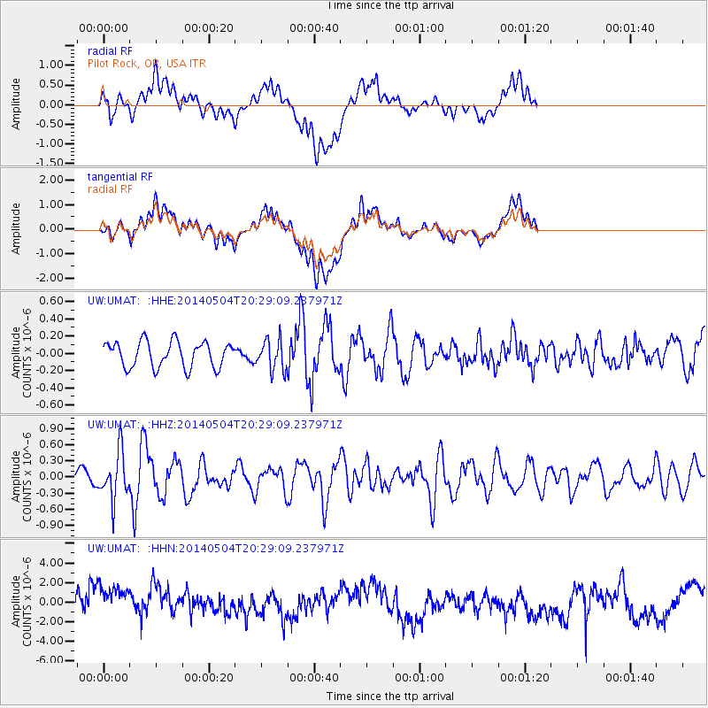
UMAT Pilot Rock, OR, USA - Earthquake Result Viewer
*The percent match for this event was below the threshold and hence no stack was calculated.
| Earthquake location: |
Near S. Coast Of Honshu, Japan |
| Earthquake latitude/longitude: |
34.9/139.3 |
| Earthquake time(UTC): |
2014/05/04 (124) 20:18:25 GMT |
| Earthquake Depth: |
156 km |
| Earthquake Magnitude: |
5.8 MB |
| Earthquake Catalog/Contributor: |
NEIC PDE/NEIC COMCAT |
|
| Network: |
UW Pacific Northwest Regional Seismic Network |
| Station: |
UMAT Pilot Rock, OR, USA |
| Lat/Lon: |
45.29 N/118.96 W |
| Elevation: |
1318 m |
|
| Distance: |
73.4 deg |
| Az: |
46.152 deg |
| Baz: |
302.881 deg |
| Ray Param: |
$rayparam |
*The percent match for this event was below the threshold and hence was not used in the summary stack. |
|
| Radial Match: |
39.677986 % |
| Radial Bump: |
400 |
| Transverse Match: |
38.70031 % |
| Transverse Bump: |
400 |
| SOD ConfigId: |
626651 |
| Insert Time: |
2014-05-18 21:19:58.620 +0000 |
| GWidth: |
2.5 |
| Max Bumps: |
400 |
| Tol: |
0.001 |
|
Signal To Noise
| Channel | StoN | STA | LTA |
| UW:UMAT: :HHZ:20140504T20:29:09.237971Z | 3.2824192 | 4.4585997E-7 | 1.3583274E-7 |
| UW:UMAT: :HHN:20140504T20:29:09.237971Z | 1.4183158 | 2.142536E-6 | 1.5106198E-6 |
| UW:UMAT: :HHE:20140504T20:29:09.237971Z | 1.1610733 | 1.7255472E-7 | 1.4861655E-7 |
| Arrivals |
| Ps | |
| PpPs | |
| PsPs/PpSs | |


