You are here: Home > Network List > TA - USArray Transportable Network (new EarthScope stations) Stations List
> Station I23K Minto, Yukon-Koyukuk, AK, USA > Earthquake Result Viewer
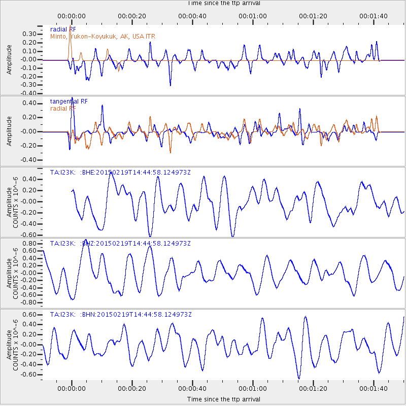
I23K Minto, Yukon-Koyukuk, AK, USA - Earthquake Result Viewer
*The percent match for this event was below the threshold and hence no stack was calculated.
| Earthquake location: |
Vanuatu Islands |
| Earthquake latitude/longitude: |
-16.5/168.0 |
| Earthquake time(UTC): |
2015/02/19 (050) 14:32:41 GMT |
| Earthquake Depth: |
10 km |
| Earthquake Magnitude: |
5.5 MB |
| Earthquake Catalog/Contributor: |
NEIC PDE/NEIC COMCAT |
|
| Network: |
TA USArray Transportable Network (new EarthScope stations) |
| Station: |
I23K Minto, Yukon-Koyukuk, AK, USA |
| Lat/Lon: |
65.15 N/149.36 W |
| Elevation: |
149 m |
|
| Distance: |
87.6 deg |
| Az: |
16.644 deg |
| Baz: |
220.547 deg |
| Ray Param: |
$rayparam |
*The percent match for this event was below the threshold and hence was not used in the summary stack. |
|
| Radial Match: |
58.52297 % |
| Radial Bump: |
400 |
| Transverse Match: |
61.912132 % |
| Transverse Bump: |
400 |
| SOD ConfigId: |
7019011 |
| Insert Time: |
2019-04-16 23:06:56.306 +0000 |
| GWidth: |
2.5 |
| Max Bumps: |
400 |
| Tol: |
0.001 |
|
Signal To Noise
| Channel | StoN | STA | LTA |
| TA:I23K: :BHZ:20150219T14:44:58.124973Z | 1.8978266 | 6.0931427E-7 | 3.21059E-7 |
| TA:I23K: :BHN:20150219T14:44:58.124973Z | 0.65598077 | 1.6673738E-7 | 2.541803E-7 |
| TA:I23K: :BHE:20150219T14:44:58.124973Z | 0.4448518 | 1.2101017E-7 | 2.7202356E-7 |
| Arrivals |
| Ps | |
| PpPs | |
| PsPs/PpSs | |


