You are here: Home > Network List > II - Global Seismograph Network (GSN - IRIS/IDA) Stations List
> Station PFO Pinon Flat, California, USA > Earthquake Result Viewer
PFO Pinon Flat, California, USA - Earthquake Result Viewer
*The percent match for this event was below the threshold and hence no stack was calculated.
| Earthquake location: |
South Of Fiji Islands |
| Earthquake latitude/longitude: |
-23.8/-179.9 |
| Earthquake time(UTC): |
1998/04/14 (104) 03:41:22 GMT |
| Earthquake Depth: |
499 km |
| Earthquake Magnitude: |
5.5 MB, 6.2 UNKNOWN, 6.1 MW |
| Earthquake Catalog/Contributor: |
WHDF/NEIC |
|
| Network: |
II Global Seismograph Network (GSN - IRIS/IDA) |
| Station: |
PFO Pinon Flat, California, USA |
| Lat/Lon: |
33.61 N/116.46 W |
| Elevation: |
1280 m |
|
| Distance: |
83.1 deg |
| Az: |
48.748 deg |
| Baz: |
235.591 deg |
| Ray Param: |
$rayparam |
*The percent match for this event was below the threshold and hence was not used in the summary stack. |
|
| Radial Match: |
68.874695 % |
| Radial Bump: |
319 |
| Transverse Match: |
46.83546 % |
| Transverse Bump: |
311 |
| SOD ConfigId: |
4480 |
| Insert Time: |
2010-03-01 21:49:14.074 +0000 |
| GWidth: |
2.5 |
| Max Bumps: |
400 |
| Tol: |
0.001 |
|
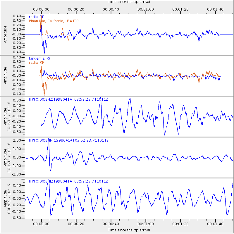
Signal To Noise
| Channel | StoN | STA | LTA |
| II:PFO:00:BHN:19980414T03:52:23.711011Z | 2.5558662 | 8.1387964E-7 | 3.1843595E-7 |
| II:PFO:00:BHE:19980414T03:52:23.711011Z | 1.5862218 | 3.1642222E-7 | 1.994817E-7 |
| II:PFO:00:BHZ:19980414T03:52:23.711011Z | 1.5130475 | 3.2116398E-7 | 2.12263E-7 |
| Arrivals |
| Ps | |
| PpPs | |
| PsPs/PpSs | |


