You are here: Home > Network List > CN - Canadian National Seismograph Network Stations List
> Station INK INUVIK, NT > Earthquake Result Viewer
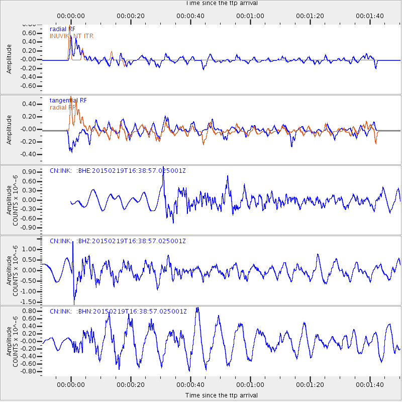
INK INUVIK, NT - Earthquake Result Viewer
*The percent match for this event was below the threshold and hence no stack was calculated.
| Earthquake location: |
Near East Coast Of Kamchatka |
| Earthquake latitude/longitude: |
52.8/159.0 |
| Earthquake time(UTC): |
2015/02/19 (050) 16:32:48 GMT |
| Earthquake Depth: |
88 km |
| Earthquake Magnitude: |
5.7 MB |
| Earthquake Catalog/Contributor: |
NEIC PDE/NEIC COMCAT |
|
| Network: |
CN Canadian National Seismograph Network |
| Station: |
INK INUVIK, NT |
| Lat/Lon: |
68.31 N/133.53 W |
| Elevation: |
44 m |
|
| Distance: |
34.5 deg |
| Az: |
37.357 deg |
| Baz: |
278.135 deg |
| Ray Param: |
$rayparam |
*The percent match for this event was below the threshold and hence was not used in the summary stack. |
|
| Radial Match: |
72.34213 % |
| Radial Bump: |
400 |
| Transverse Match: |
78.00589 % |
| Transverse Bump: |
400 |
| SOD ConfigId: |
7019011 |
| Insert Time: |
2019-04-16 23:11:41.755 +0000 |
| GWidth: |
2.5 |
| Max Bumps: |
400 |
| Tol: |
0.001 |
|
Signal To Noise
| Channel | StoN | STA | LTA |
| CN:INK: :BHZ:20150219T16:38:57.025001Z | 2.639408 | 6.214199E-7 | 2.3543909E-7 |
| CN:INK: :BHN:20150219T16:38:57.025001Z | 1.3438718 | 1.5447802E-7 | 1.1494996E-7 |
| CN:INK: :BHE:20150219T16:38:57.025001Z | 2.5501242 | 4.28942E-7 | 1.6820437E-7 |
| Arrivals |
| Ps | |
| PpPs | |
| PsPs/PpSs | |


