You are here: Home > Network List > II - Global Seismograph Network (GSN - IRIS/IDA) Stations List
> Station PFO Pinon Flat, California, USA > Earthquake Result Viewer
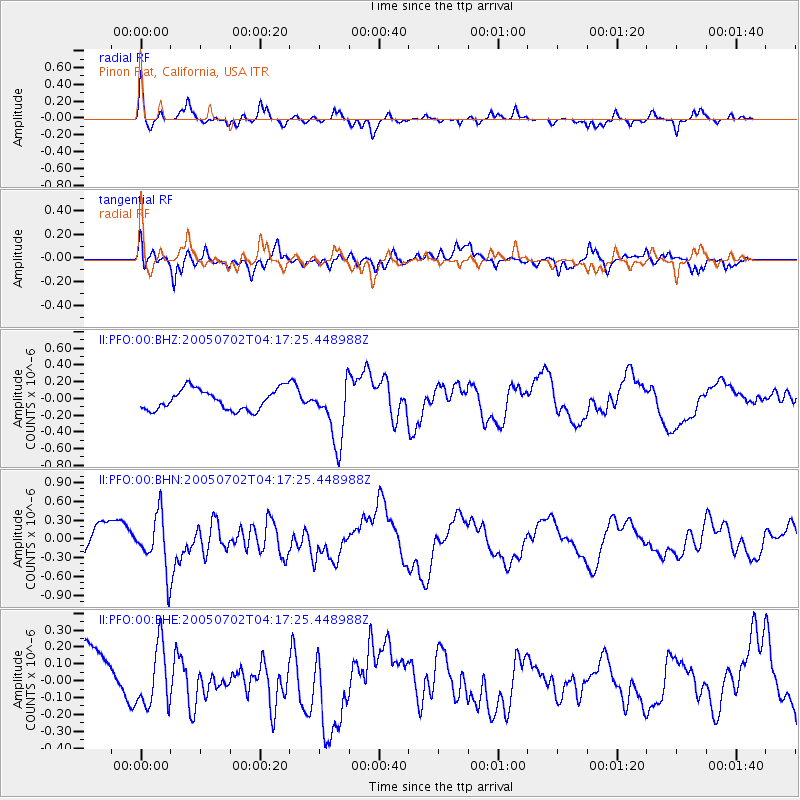
PFO Pinon Flat, California, USA - Earthquake Result Viewer
*The percent match for this event was below the threshold and hence no stack was calculated.
| Earthquake location: |
Near Coast Of Nicaragua |
| Earthquake latitude/longitude: |
11.4/-86.3 |
| Earthquake time(UTC): |
2005/07/02 (183) 04:11:04 GMT |
| Earthquake Depth: |
40 km |
| Earthquake Magnitude: |
5.4 MB, 5.4 MS, 5.8 MW, 5.0 MD |
| Earthquake Catalog/Contributor: |
WHDF/NEIC |
|
| Network: |
II Global Seismograph Network (GSN - IRIS/IDA) |
| Station: |
PFO Pinon Flat, California, USA |
| Lat/Lon: |
33.61 N/116.46 W |
| Elevation: |
1280 m |
|
| Distance: |
35.4 deg |
| Az: |
313.505 deg |
| Baz: |
121.551 deg |
| Ray Param: |
$rayparam |
*The percent match for this event was below the threshold and hence was not used in the summary stack. |
|
| Radial Match: |
77.92097 % |
| Radial Bump: |
365 |
| Transverse Match: |
65.960594 % |
| Transverse Bump: |
400 |
| SOD ConfigId: |
3128 |
| Insert Time: |
2010-03-01 21:49:20.049 +0000 |
| GWidth: |
2.5 |
| Max Bumps: |
400 |
| Tol: |
0.001 |
|
Signal To Noise
| Channel | StoN | STA | LTA |
| II:PFO:00:BHN:20050702T04:17:25.448988Z | 1.896294 | 4.351614E-7 | 2.2947992E-7 |
| II:PFO:00:BHE:20050702T04:17:25.448988Z | 0.93099916 | 1.7953776E-7 | 1.9284417E-7 |
| II:PFO:00:BHZ:20050702T04:17:25.448988Z | 3.004807 | 3.7109248E-7 | 1.234996E-7 |
| Arrivals |
| Ps | |
| PpPs | |
| PsPs/PpSs | |


