You are here: Home > Network List > IU - Global Seismograph Network (GSN - IRIS/USGS) Stations List
> Station PMG Port Moresby, New Guinea > Earthquake Result Viewer
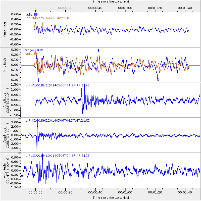
PMG Port Moresby, New Guinea - Earthquake Result Viewer
*The percent match for this event was below the threshold and hence no stack was calculated.
| Earthquake location: |
Fiji Islands Region |
| Earthquake latitude/longitude: |
-20.1/-177.7 |
| Earthquake time(UTC): |
2014/05/06 (126) 04:32:06 GMT |
| Earthquake Depth: |
552 km |
| Earthquake Magnitude: |
5.7 MB |
| Earthquake Catalog/Contributor: |
NEIC PDE/NEIC COMCAT |
|
| Network: |
IU Global Seismograph Network (GSN - IRIS/USGS) |
| Station: |
PMG Port Moresby, New Guinea |
| Lat/Lon: |
9.40 S/147.16 E |
| Elevation: |
90 m |
|
| Distance: |
35.6 deg |
| Az: |
282.186 deg |
| Baz: |
111.398 deg |
| Ray Param: |
$rayparam |
*The percent match for this event was below the threshold and hence was not used in the summary stack. |
|
| Radial Match: |
45.02793 % |
| Radial Bump: |
400 |
| Transverse Match: |
48.603733 % |
| Transverse Bump: |
400 |
| SOD ConfigId: |
626651 |
| Insert Time: |
2014-05-20 05:03:34.130 +0000 |
| GWidth: |
2.5 |
| Max Bumps: |
400 |
| Tol: |
0.001 |
|
Signal To Noise
| Channel | StoN | STA | LTA |
| IU:PMG:00:BHZ:20140506T04:37:47.219Z | 7.7784076 | 1.2159167E-6 | 1.5631949E-7 |
| IU:PMG:00:BH1:20140506T04:37:47.219Z | 1.8008144 | 4.3803118E-7 | 2.432406E-7 |
| IU:PMG:00:BH2:20140506T04:37:47.219Z | 3.2947502 | 6.432605E-7 | 1.9523802E-7 |
| Arrivals |
| Ps | |
| PpPs | |
| PsPs/PpSs | |


