You are here: Home > Network List > TA - USArray Transportable Network (new EarthScope stations) Stations List
> Station 121A Cookes Peak, Deming, NM, USA > Earthquake Result Viewer
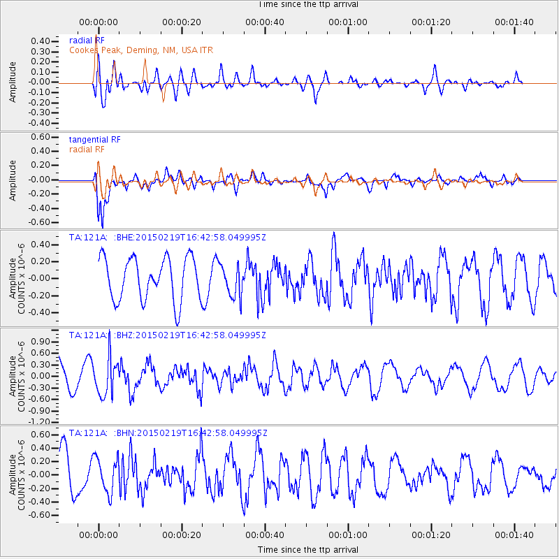
121A Cookes Peak, Deming, NM, USA - Earthquake Result Viewer
*The percent match for this event was below the threshold and hence no stack was calculated.
| Earthquake location: |
Near East Coast Of Kamchatka |
| Earthquake latitude/longitude: |
52.8/159.0 |
| Earthquake time(UTC): |
2015/02/19 (050) 16:32:48 GMT |
| Earthquake Depth: |
88 km |
| Earthquake Magnitude: |
5.7 MB |
| Earthquake Catalog/Contributor: |
NEIC PDE/NEIC COMCAT |
|
| Network: |
TA USArray Transportable Network (new EarthScope stations) |
| Station: |
121A Cookes Peak, Deming, NM, USA |
| Lat/Lon: |
32.53 N/107.79 W |
| Elevation: |
1652 m |
|
| Distance: |
66.6 deg |
| Az: |
66.735 deg |
| Baz: |
318.725 deg |
| Ray Param: |
$rayparam |
*The percent match for this event was below the threshold and hence was not used in the summary stack. |
|
| Radial Match: |
52.599686 % |
| Radial Bump: |
400 |
| Transverse Match: |
74.519554 % |
| Transverse Bump: |
400 |
| SOD ConfigId: |
7019011 |
| Insert Time: |
2019-04-16 23:16:14.926 +0000 |
| GWidth: |
2.5 |
| Max Bumps: |
400 |
| Tol: |
0.001 |
|
Signal To Noise
| Channel | StoN | STA | LTA |
| TA:121A: :BHZ:20150219T16:42:58.049995Z | 1.445361 | 4.879723E-7 | 3.376127E-7 |
| TA:121A: :BHN:20150219T16:42:58.049995Z | 0.69400275 | 2.5722233E-7 | 3.706359E-7 |
| TA:121A: :BHE:20150219T16:42:58.049995Z | 0.6983865 | 1.749839E-7 | 2.5055454E-7 |
| Arrivals |
| Ps | |
| PpPs | |
| PsPs/PpSs | |


