You are here: Home > Network List > UW - Pacific Northwest Regional Seismic Network Stations List
> Station HOOD Mt Hood Meadows, OR CREST BB SMO > Earthquake Result Viewer
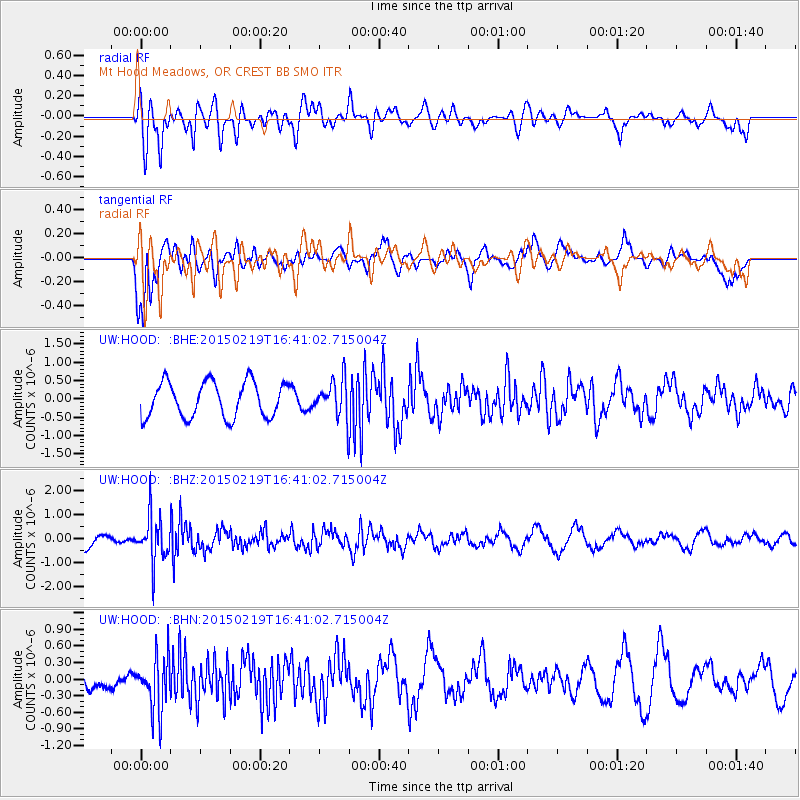
HOOD Mt Hood Meadows, OR CREST BB SMO - Earthquake Result Viewer
*The percent match for this event was below the threshold and hence no stack was calculated.
| Earthquake location: |
Near East Coast Of Kamchatka |
| Earthquake latitude/longitude: |
52.8/159.0 |
| Earthquake time(UTC): |
2015/02/19 (050) 16:32:48 GMT |
| Earthquake Depth: |
88 km |
| Earthquake Magnitude: |
5.7 MB |
| Earthquake Catalog/Contributor: |
NEIC PDE/NEIC COMCAT |
|
| Network: |
UW Pacific Northwest Regional Seismic Network |
| Station: |
HOOD Mt Hood Meadows, OR CREST BB SMO |
| Lat/Lon: |
45.32 N/121.65 W |
| Elevation: |
1520 m |
|
| Distance: |
50.0 deg |
| Az: |
64.791 deg |
| Baz: |
308.934 deg |
| Ray Param: |
$rayparam |
*The percent match for this event was below the threshold and hence was not used in the summary stack. |
|
| Radial Match: |
62.003124 % |
| Radial Bump: |
400 |
| Transverse Match: |
69.8783 % |
| Transverse Bump: |
400 |
| SOD ConfigId: |
7019011 |
| Insert Time: |
2019-04-16 23:17:59.066 +0000 |
| GWidth: |
2.5 |
| Max Bumps: |
400 |
| Tol: |
0.001 |
|
Signal To Noise
| Channel | StoN | STA | LTA |
| UW:HOOD: :BHZ:20150219T16:41:02.715004Z | 2.1632402 | 9.581901E-7 | 4.4294202E-7 |
| UW:HOOD: :BHN:20150219T16:41:02.715004Z | 1.4427904 | 4.9642273E-7 | 3.4407128E-7 |
| UW:HOOD: :BHE:20150219T16:41:02.715004Z | 1.2409691 | 5.868809E-7 | 4.7292144E-7 |
| Arrivals |
| Ps | |
| PpPs | |
| PsPs/PpSs | |


