You are here: Home > Network List > UW - Pacific Northwest Regional Seismic Network Stations List
> Station LEBA Lebam, WA, USA > Earthquake Result Viewer
LEBA Lebam, WA, USA - Earthquake Result Viewer
*The percent match for this event was below the threshold and hence no stack was calculated.
| Earthquake location: |
Near East Coast Of Kamchatka |
| Earthquake latitude/longitude: |
52.8/159.0 |
| Earthquake time(UTC): |
2015/02/19 (050) 16:32:48 GMT |
| Earthquake Depth: |
88 km |
| Earthquake Magnitude: |
5.7 MB |
| Earthquake Catalog/Contributor: |
NEIC PDE/NEIC COMCAT |
|
| Network: |
UW Pacific Northwest Regional Seismic Network |
| Station: |
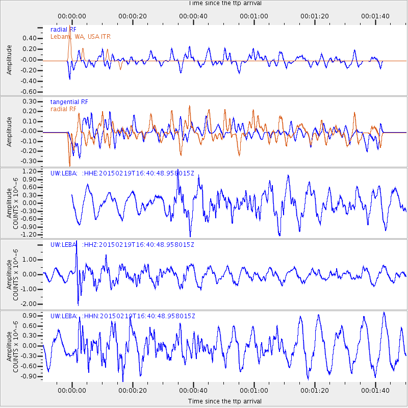
LEBA Lebam, WA, USA |
| Lat/Lon: |
46.55 N/123.56 W |
| Elevation: |
73 m |
|
| Distance: |
48.2 deg |
| Az: |
64.608 deg |
| Baz: |
307.447 deg |
| Ray Param: |
$rayparam |
*The percent match for this event was below the threshold and hence was not used in the summary stack. |
|
| Radial Match: |
60.5051 % |
| Radial Bump: |
400 |
| Transverse Match: |
61.197918 % |
| Transverse Bump: |
400 |
| SOD ConfigId: |
7019011 |
| Insert Time: |
2019-04-16 23:18:00.601 +0000 |
| GWidth: |
2.5 |
| Max Bumps: |
400 |
| Tol: |
0.001 |
|
Signal To Noise
| Channel | StoN | STA | LTA |
| UW:LEBA: :HHZ:20150219T16:40:48.958015Z | 2.1653738 | 8.1431614E-7 | 3.7606262E-7 |
| UW:LEBA: :HHN:20150219T16:40:48.958015Z | 1.1952198 | 3.5113547E-7 | 2.937832E-7 |
| UW:LEBA: :HHE:20150219T16:40:48.958015Z | 1.2825243 | 4.6541672E-7 | 3.6289114E-7 |
| Arrivals |
| Ps | |
| PpPs | |
| PsPs/PpSs | |


