You are here: Home > Network List > AU - Australian Seismological Centre Stations List
> Station PSAD2 Pilbara Seismic Array Element D2 > Earthquake Result Viewer
PSAD2 Pilbara Seismic Array Element D2 - Earthquake Result Viewer
| Earthquake location: |
Solomon Islands |
| Earthquake latitude/longitude: |
-6.9/154.9 |
| Earthquake time(UTC): |
2014/05/07 (127) 04:20:33 GMT |
| Earthquake Depth: |
1.0 km |
| Earthquake Magnitude: |
6.1 MWP |
| Earthquake Catalog/Contributor: |
NEIC PDE/NEIC COMCAT |
|
| Network: |
AU Australian Seismological Centre |
| Station: |
PSAD2 Pilbara Seismic Array Element D2 |
| Lat/Lon: |
21.62 S/119.96 E |
| Elevation: |
366 m |
|
| Distance: |
36.7 deg |
| Az: |
242.956 deg |
| Baz: |
71.848 deg |
| Ray Param: |
0.076545015 |
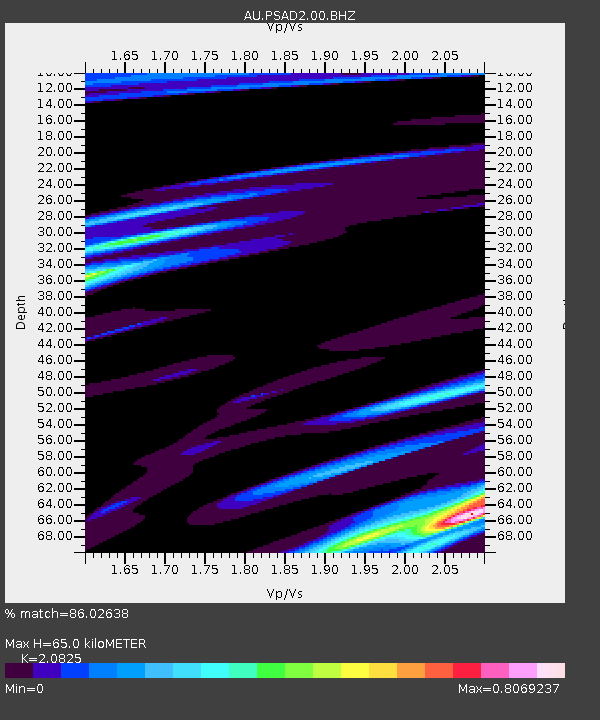
| Estimated Moho Depth: |
65.0 km |
| Estimated Crust Vp/Vs: |
2.08 |
| Assumed Crust Vp: |
6.464 km/s |
| Estimated Crust Vs: |
3.104 km/s |
| Estimated Crust Poisson's Ratio: |
0.35 |
|
| Radial Match: |
86.02638 % |
| Radial Bump: |
370 |
| Transverse Match: |
71.96745 % |
| Transverse Bump: |
400 |
| SOD ConfigId: |
626651 |
| Insert Time: |
2014-05-21 04:40:53.443 +0000 |
| GWidth: |
2.5 |
| Max Bumps: |
400 |
| Tol: |
0.001 |
|

Signal To Noise
| Channel | StoN | STA | LTA |
| AU:PSAD2:00:BHZ:20140507T04:27:11.544004Z | 4.9146094 | 1.8859809E-6 | 3.837499E-7 |
| AU:PSAD2:00:BH1:20140507T04:27:11.544004Z | 7.7931576 | 1.0752779E-6 | 1.3797718E-7 |
| AU:PSAD2:00:BH2:20140507T04:27:11.544004Z | 2.4969492 | 3.148276E-7 | 1.260849E-7 |
| Arrivals |
| Ps | 12 SECOND |
| PpPs | 29 SECOND |
| PsPs/PpSs | 41 SECOND |


