You are here: Home > Network List > II - Global Seismograph Network (GSN - IRIS/IDA) Stations List
> Station PFO Pinon Flat, California, USA > Earthquake Result Viewer
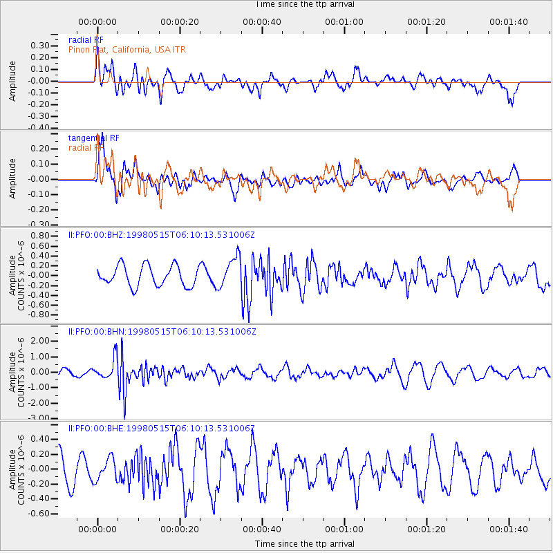
PFO Pinon Flat, California, USA - Earthquake Result Viewer
*The percent match for this event was below the threshold and hence no stack was calculated.
| Earthquake location: |
Mariana Islands |
| Earthquake latitude/longitude: |
14.2/144.9 |
| Earthquake time(UTC): |
1998/05/15 (135) 05:58:06 GMT |
| Earthquake Depth: |
154 km |
| Earthquake Magnitude: |
5.7 MB, 6.0 UNKNOWN, 6.0 MW |
| Earthquake Catalog/Contributor: |
WHDF/NEIC |
|
| Network: |
II Global Seismograph Network (GSN - IRIS/IDA) |
| Station: |
PFO Pinon Flat, California, USA |
| Lat/Lon: |
33.61 N/116.46 W |
| Elevation: |
1280 m |
|
| Distance: |
89.3 deg |
| Az: |
55.596 deg |
| Baz: |
286.478 deg |
| Ray Param: |
$rayparam |
*The percent match for this event was below the threshold and hence was not used in the summary stack. |
|
| Radial Match: |
61.803444 % |
| Radial Bump: |
400 |
| Transverse Match: |
73.57487 % |
| Transverse Bump: |
390 |
| SOD ConfigId: |
4480 |
| Insert Time: |
2010-03-01 21:50:00.900 +0000 |
| GWidth: |
2.5 |
| Max Bumps: |
400 |
| Tol: |
0.001 |
|
Signal To Noise
| Channel | StoN | STA | LTA |
| II:PFO:00:BHN:19980515T06:10:13.531006Z | 4.3182516 | 6.895588E-7 | 1.5968473E-7 |
| II:PFO:00:BHE:19980515T06:10:13.531006Z | 0.765775 | 1.4816823E-7 | 1.9348794E-7 |
| II:PFO:00:BHZ:19980515T06:10:13.531006Z | 1.5330071 | 3.1547376E-7 | 2.0578753E-7 |
| Arrivals |
| Ps | |
| PpPs | |
| PsPs/PpSs | |


