You are here: Home > Network List > IM - International Miscellaneous Stations Stations List
> Station MK31 Makanchi Array Site 31, Kazakhstan > Earthquake Result Viewer
MK31 Makanchi Array Site 31, Kazakhstan - Earthquake Result Viewer
| Earthquake location: |
Solomon Islands |
| Earthquake latitude/longitude: |
-6.9/154.9 |
| Earthquake time(UTC): |
2014/05/07 (127) 04:20:33 GMT |
| Earthquake Depth: |
1.0 km |
| Earthquake Magnitude: |
6.1 MWP |
| Earthquake Catalog/Contributor: |
NEIC PDE/NEIC COMCAT |
|
| Network: |
IM International Miscellaneous Stations |
| Station: |
MK31 Makanchi Array Site 31, Kazakhstan |
| Lat/Lon: |
46.79 N/82.29 E |
| Elevation: |
618 m |
|
| Distance: |
83.3 deg |
| Az: |
318.692 deg |
| Baz: |
107.486 deg |
| Ray Param: |
0.046306398 |
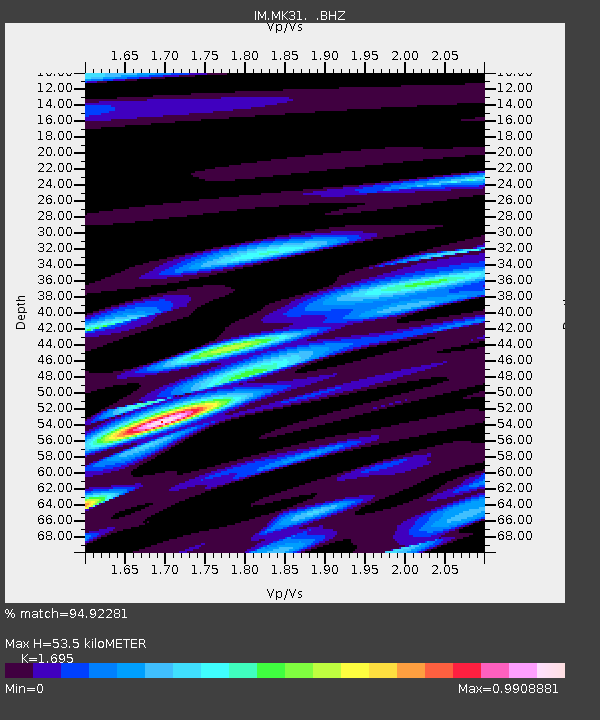
| Estimated Moho Depth: |
53.5 km |
| Estimated Crust Vp/Vs: |
1.70 |
| Assumed Crust Vp: |
6.688 km/s |
| Estimated Crust Vs: |
3.946 km/s |
| Estimated Crust Poisson's Ratio: |
0.23 |
|
| Radial Match: |
94.92281 % |
| Radial Bump: |
400 |
| Transverse Match: |
92.298996 % |
| Transverse Bump: |
400 |
| SOD ConfigId: |
626651 |
| Insert Time: |
2014-05-21 04:47:37.152 +0000 |
| GWidth: |
2.5 |
| Max Bumps: |
400 |
| Tol: |
0.001 |
|

Signal To Noise
| Channel | StoN | STA | LTA |
| IM:MK31: :BHZ:20140507T04:32:30.549985Z | 20.949709 | 3.1093904E-8 | 1.4842165E-9 |
| IM:MK31: :BHN:20140507T04:32:30.549985Z | 2.5885959 | 3.2277983E-9 | 1.2469301E-9 |
| IM:MK31: :BHE:20140507T04:32:30.549985Z | 8.23295 | 9.347826E-9 | 1.1354163E-9 |
| Arrivals |
| Ps | 5.7 SECOND |
| PpPs | 21 SECOND |
| PsPs/PpSs | 27 SECOND |


