You are here: Home > Network List > IU - Global Seismograph Network (GSN - IRIS/USGS) Stations List
> Station MBWA Marble Bar, Western Australia > Earthquake Result Viewer
MBWA Marble Bar, Western Australia - Earthquake Result Viewer
| Earthquake location: |
Solomon Islands |
| Earthquake latitude/longitude: |
-6.9/154.9 |
| Earthquake time(UTC): |
2014/05/07 (127) 04:20:33 GMT |
| Earthquake Depth: |
1.0 km |
| Earthquake Magnitude: |
6.1 MWP |
| Earthquake Catalog/Contributor: |
NEIC PDE/NEIC COMCAT |
|
| Network: |
IU Global Seismograph Network (GSN - IRIS/USGS) |
| Station: |
MBWA Marble Bar, Western Australia |
| Lat/Lon: |
21.16 S/119.73 E |
| Elevation: |
190 m |
|
| Distance: |
36.8 deg |
| Az: |
243.791 deg |
| Baz: |
72.601 deg |
| Ray Param: |
0.07650909 |
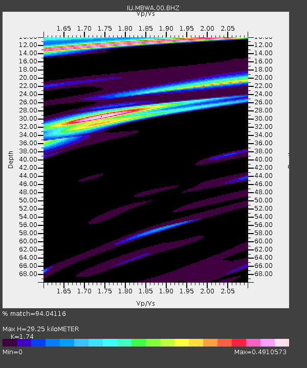
| Estimated Moho Depth: |
29.25 km |
| Estimated Crust Vp/Vs: |
1.74 |
| Assumed Crust Vp: |
6.464 km/s |
| Estimated Crust Vs: |
3.715 km/s |
| Estimated Crust Poisson's Ratio: |
0.25 |
|
| Radial Match: |
94.04116 % |
| Radial Bump: |
258 |
| Transverse Match: |
69.237816 % |
| Transverse Bump: |
400 |
| SOD ConfigId: |
626651 |
| Insert Time: |
2014-05-21 04:48:20.809 +0000 |
| GWidth: |
2.5 |
| Max Bumps: |
400 |
| Tol: |
0.001 |
|

Signal To Noise
| Channel | StoN | STA | LTA |
| IU:MBWA:00:BHZ:20140507T04:27:12.118986Z | 8.892153 | 1.5807815E-6 | 1.7777265E-7 |
| IU:MBWA:00:BH1:20140507T04:27:12.118986Z | 2.7656808 | 5.023982E-7 | 1.8165446E-7 |
| IU:MBWA:00:BH2:20140507T04:27:12.118986Z | 5.997303 | 9.676457E-7 | 1.6134683E-7 |
| Arrivals |
| Ps | 3.6 SECOND |
| PpPs | 11 SECOND |
| PsPs/PpSs | 15 SECOND |


