You are here: Home > Network List > II - Global Seismograph Network (GSN - IRIS/IDA) Stations List
> Station PFO Pinon Flat, California, USA > Earthquake Result Viewer
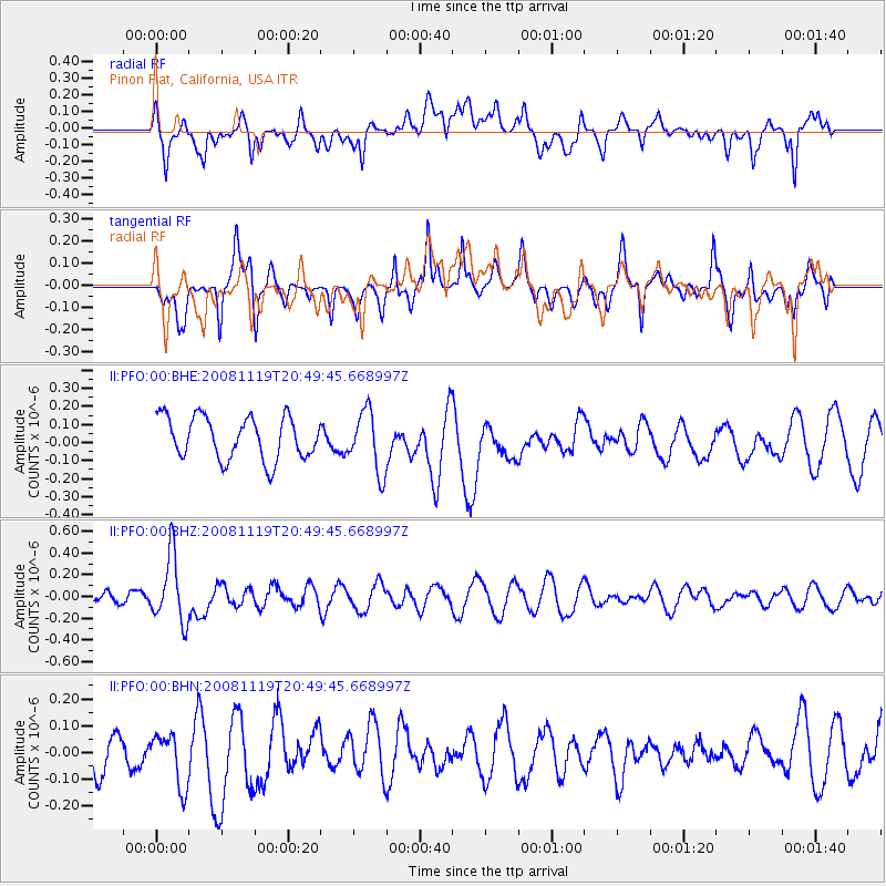
PFO Pinon Flat, California, USA - Earthquake Result Viewer
*The percent match for this event was below the threshold and hence no stack was calculated.
| Earthquake location: |
South Of Fiji Islands |
| Earthquake latitude/longitude: |
-22.2/-179.7 |
| Earthquake time(UTC): |
2008/11/19 (324) 20:38:58 GMT |
| Earthquake Depth: |
596 km |
| Earthquake Magnitude: |
5.8 MW, 5.2 MB, 5.8 MW |
| Earthquake Catalog/Contributor: |
WHDF/NEIC |
|
| Network: |
II Global Seismograph Network (GSN - IRIS/IDA) |
| Station: |
PFO Pinon Flat, California, USA |
| Lat/Lon: |
33.61 N/116.46 W |
| Elevation: |
1280 m |
|
| Distance: |
81.9 deg |
| Az: |
48.838 deg |
| Baz: |
236.745 deg |
| Ray Param: |
$rayparam |
*The percent match for this event was below the threshold and hence was not used in the summary stack. |
|
| Radial Match: |
60.066326 % |
| Radial Bump: |
400 |
| Transverse Match: |
77.487755 % |
| Transverse Bump: |
400 |
| SOD ConfigId: |
2658 |
| Insert Time: |
2010-03-01 21:50:20.125 +0000 |
| GWidth: |
2.5 |
| Max Bumps: |
400 |
| Tol: |
0.001 |
|
Signal To Noise
| Channel | StoN | STA | LTA |
| II:PFO:00:BHZ:20081119T20:49:45.668997Z | 2.4083083 | 3.0988653E-7 | 1.2867395E-7 |
| II:PFO:00:BHN:20081119T20:49:45.668997Z | 1.0916077 | 9.834724E-8 | 9.009395E-8 |
| II:PFO:00:BHE:20081119T20:49:45.668997Z | 1.4432255 | 1.6896855E-7 | 1.1707703E-7 |
| Arrivals |
| Ps | |
| PpPs | |
| PsPs/PpSs | |


