You are here: Home > Network List > II - Global Seismograph Network (GSN - IRIS/IDA) Stations List
> Station PFO Pinon Flat, California, USA > Earthquake Result Viewer
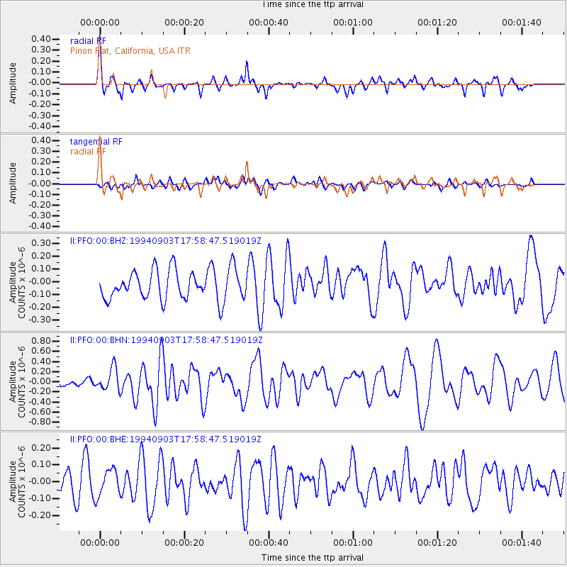
PFO Pinon Flat, California, USA - Earthquake Result Viewer
*The percent match for this event was below the threshold and hence no stack was calculated.
| Earthquake location: |
Vanuatu Islands Region |
| Earthquake latitude/longitude: |
-21.3/173.6 |
| Earthquake time(UTC): |
1994/09/03 (246) 17:46:41 GMT |
| Earthquake Depth: |
33 km |
| Earthquake Magnitude: |
5.7 MB, 6.2 MS, 6.3 UNKNOWN, 6.2 MW |
| Earthquake Catalog/Contributor: |
WHDF/NEIC |
|
| Network: |
II Global Seismograph Network (GSN - IRIS/IDA) |
| Station: |
PFO Pinon Flat, California, USA |
| Lat/Lon: |
33.61 N/116.46 W |
| Elevation: |
1280 m |
|
| Distance: |
86.1 deg |
| Az: |
51.774 deg |
| Baz: |
241.398 deg |
| Ray Param: |
$rayparam |
*The percent match for this event was below the threshold and hence was not used in the summary stack. |
|
| Radial Match: |
77.03662 % |
| Radial Bump: |
349 |
| Transverse Match: |
58.159473 % |
| Transverse Bump: |
400 |
| SOD ConfigId: |
4480 |
| Insert Time: |
2010-03-01 21:50:24.412 +0000 |
| GWidth: |
2.5 |
| Max Bumps: |
400 |
| Tol: |
0.001 |
|
Signal To Noise
| Channel | StoN | STA | LTA |
| II:PFO:00:BHN:19940903T17:58:47.519019Z | 2.0706336 | 2.2844621E-7 | 1.10326724E-7 |
| II:PFO:00:BHE:19940903T17:58:47.519019Z | 0.9794734 | 7.927624E-8 | 8.093761E-8 |
| II:PFO:00:BHZ:19940903T17:58:47.519019Z | 1.3224276 | 1.3754426E-7 | 1.0400891E-7 |
| Arrivals |
| Ps | |
| PpPs | |
| PsPs/PpSs | |


