You are here: Home > Network List > TA - USArray Transportable Network (new EarthScope stations) Stations List
> Station O03E Paynes Creek, CA, USA > Earthquake Result Viewer
O03E Paynes Creek, CA, USA - Earthquake Result Viewer
*The percent match for this event was below the threshold and hence no stack was calculated.
| Earthquake location: |
Solomon Islands |
| Earthquake latitude/longitude: |
-6.9/154.9 |
| Earthquake time(UTC): |
2014/05/07 (127) 04:20:33 GMT |
| Earthquake Depth: |
1.0 km |
| Earthquake Magnitude: |
6.1 MWP |
| Earthquake Catalog/Contributor: |
NEIC PDE/NEIC COMCAT |
|
| Network: |
TA USArray Transportable Network (new EarthScope stations) |
| Station: |
O03E Paynes Creek, CA, USA |
| Lat/Lon: |
40.29 N/121.80 W |
| Elevation: |
967 m |
|
| Distance: |
89.4 deg |
| Az: |
49.439 deg |
| Baz: |
260.424 deg |
| Ray Param: |
$rayparam |
*The percent match for this event was below the threshold and hence was not used in the summary stack. |
|
| Radial Match: |
63.037285 % |
| Radial Bump: |
312 |
| Transverse Match: |
66.68662 % |
| Transverse Bump: |
400 |
| SOD ConfigId: |
626651 |
| Insert Time: |
2014-05-21 04:54:06.988 +0000 |
| GWidth: |
2.5 |
| Max Bumps: |
400 |
| Tol: |
0.001 |
|
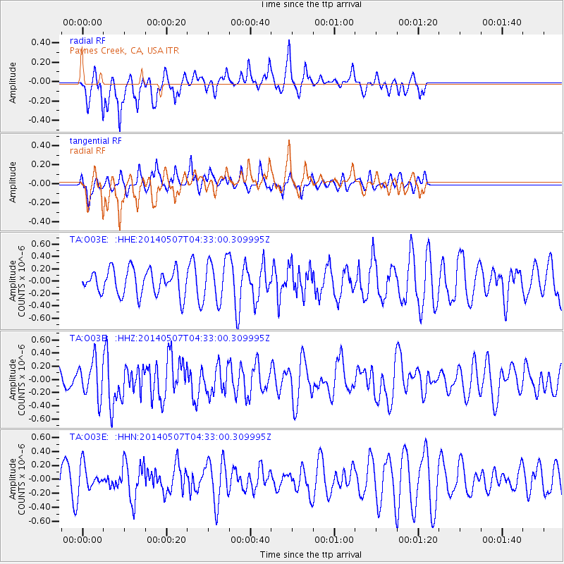
Signal To Noise
| Channel | StoN | STA | LTA |
| TA:O03E: :HHZ:20140507T04:33:00.309995Z | 2.0996897 | 2.8332488E-7 | 1.3493654E-7 |
| TA:O03E: :HHN:20140507T04:33:00.309995Z | 1.3546673 | 1.7491045E-7 | 1.2911691E-7 |
| TA:O03E: :HHE:20140507T04:33:00.309995Z | 1.6089426 | 3.2717958E-7 | 2.0335068E-7 |
| Arrivals |
| Ps | |
| PpPs | |
| PsPs/PpSs | |


