You are here: Home > Network List > AK - Alaska Regional Network Stations List
> Station CCB Clear Creek Butte > Earthquake Result Viewer
CCB Clear Creek Butte - Earthquake Result Viewer
| Earthquake location: |
Off East Coast Of Honshu, Japan |
| Earthquake latitude/longitude: |
39.8/143.6 |
| Earthquake time(UTC): |
2015/02/20 (051) 04:25:24 GMT |
| Earthquake Depth: |
14 km |
| Earthquake Magnitude: |
6.3 MWP |
| Earthquake Catalog/Contributor: |
NEIC PDE/NEIC COMCAT |
|
| Network: |
AK Alaska Regional Network |
| Station: |
CCB Clear Creek Butte |
| Lat/Lon: |
64.65 N/147.80 W |
| Elevation: |
248 m |
|
| Distance: |
45.8 deg |
| Az: |
33.988 deg |
| Baz: |
271.723 deg |
| Ray Param: |
0.07101329 |
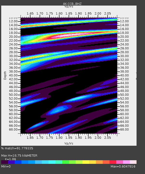
| Estimated Moho Depth: |
18.75 km |
| Estimated Crust Vp/Vs: |
1.86 |
| Assumed Crust Vp: |
6.566 km/s |
| Estimated Crust Vs: |
3.53 km/s |
| Estimated Crust Poisson's Ratio: |
0.30 |
|
| Radial Match: |
91.779335 % |
| Radial Bump: |
400 |
| Transverse Match: |
53.32533 % |
| Transverse Bump: |
400 |
| SOD ConfigId: |
7019011 |
| Insert Time: |
2019-04-16 23:21:52.420 +0000 |
| GWidth: |
2.5 |
| Max Bumps: |
400 |
| Tol: |
0.001 |
|

Signal To Noise
| Channel | StoN | STA | LTA |
| AK:CCB: :BHZ:20150220T04:33:14.448Z | 3.3683069 | 4.835943E-7 | 1.4357192E-7 |
| AK:CCB: :BHN:20150220T04:33:14.448Z | 0.85270953 | 1.4658146E-7 | 1.7190081E-7 |
| AK:CCB: :BHE:20150220T04:33:14.448Z | 1.8881128 | 2.509837E-7 | 1.3292835E-7 |
| Arrivals |
| Ps | 2.6 SECOND |
| PpPs | 7.7 SECOND |
| PsPs/PpSs | 10 SECOND |


