You are here: Home > Network List > UW - Pacific Northwest Regional Seismic Network Stations List
> Station LEBA Lebam, WA, USA > Earthquake Result Viewer
LEBA Lebam, WA, USA - Earthquake Result Viewer
*The percent match for this event was below the threshold and hence no stack was calculated.
| Earthquake location: |
Solomon Islands |
| Earthquake latitude/longitude: |
-7.0/154.8 |
| Earthquake time(UTC): |
2014/05/07 (127) 04:45:00 GMT |
| Earthquake Depth: |
10 km |
| Earthquake Magnitude: |
5.6 MB |
| Earthquake Catalog/Contributor: |
NEIC PDE/NEIC COMCAT |
|
| Network: |
UW Pacific Northwest Regional Seismic Network |
| Station: |
LEBA Lebam, WA, USA |
| Lat/Lon: |
46.55 N/123.56 W |
| Elevation: |
73 m |
|
| Distance: |
89.3 deg |
| Az: |
43.069 deg |
| Baz: |
259.141 deg |
| Ray Param: |
$rayparam |
*The percent match for this event was below the threshold and hence was not used in the summary stack. |
|
| Radial Match: |
63.485966 % |
| Radial Bump: |
357 |
| Transverse Match: |
61.35238 % |
| Transverse Bump: |
345 |
| SOD ConfigId: |
626651 |
| Insert Time: |
2014-05-21 05:14:16.439 +0000 |
| GWidth: |
2.5 |
| Max Bumps: |
400 |
| Tol: |
0.001 |
|
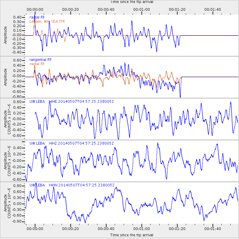
Signal To Noise
| Channel | StoN | STA | LTA |
| UW:LEBA: :HHZ:20140507T04:57:25.238005Z | 1.1407098 | 2.352389E-7 | 2.0622153E-7 |
| UW:LEBA: :HHN:20140507T04:57:25.238005Z | 2.3997915 | 6.846557E-7 | 2.85298E-7 |
| UW:LEBA: :HHE:20140507T04:57:25.238005Z | 1.3268064 | 3.272629E-7 | 2.466546E-7 |
| Arrivals |
| Ps | |
| PpPs | |
| PsPs/PpSs | |


