You are here: Home > Network List > CI - Caltech Regional Seismic Network Stations List
> Station VCS Vincent Substation, Palmdale, CA, USA > Earthquake Result Viewer
VCS Vincent Substation, Palmdale, CA, USA - Earthquake Result Viewer
| Earthquake location: |
Santiago Del Estero Prov., Arg. |
| Earthquake latitude/longitude: |
-28.3/-63.0 |
| Earthquake time(UTC): |
2000/04/23 (114) 09:27:23 GMT |
| Earthquake Depth: |
608 km |
| Earthquake Magnitude: |
6.6 MB, 7.0 MW, 7.0 MW |
| Earthquake Catalog/Contributor: |
WHDF/NEIC |
|
| Network: |
CI Caltech Regional Seismic Network |
| Station: |
VCS Vincent Substation, Palmdale, CA, USA |
| Lat/Lon: |
34.48 N/118.12 W |
| Elevation: |
991 m |
|
| Distance: |
81.3 deg |
| Az: |
316.722 deg |
| Baz: |
132.967 deg |
| Ray Param: |
0.045786258 |
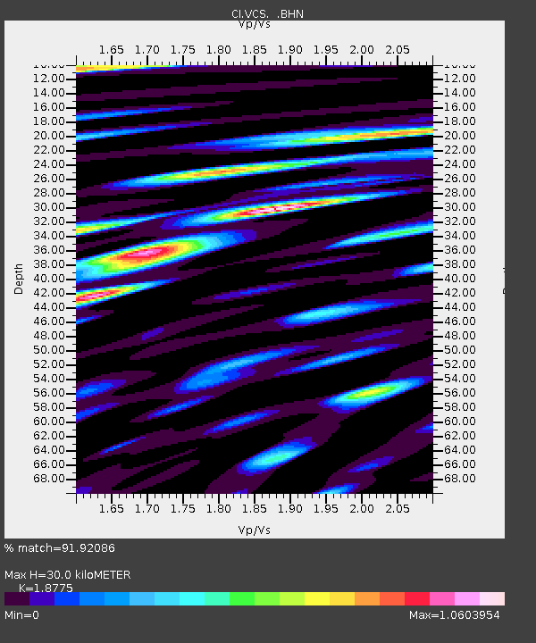
| Estimated Moho Depth: |
30.0 km |
| Estimated Crust Vp/Vs: |
1.88 |
| Assumed Crust Vp: |
6.1 km/s |
| Estimated Crust Vs: |
3.249 km/s |
| Estimated Crust Poisson's Ratio: |
0.30 |
|
| Radial Match: |
91.92086 % |
| Radial Bump: |
400 |
| Transverse Match: |
75.51647 % |
| Transverse Bump: |
400 |
| SOD ConfigId: |
3787 |
| Insert Time: |
2010-02-25 21:03:46.701 +0000 |
| GWidth: |
2.5 |
| Max Bumps: |
400 |
| Tol: |
0.001 |
|
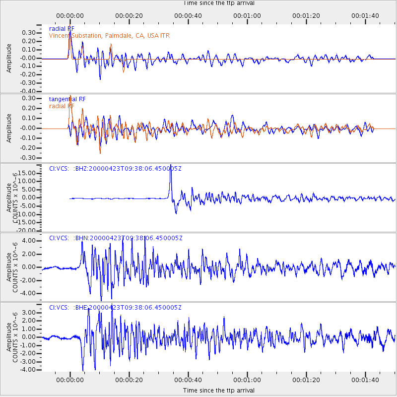
Signal To Noise
| Channel | StoN | STA | LTA |
| CI:VCS: :BHN:20000423T09:38:06.450005Z | 6.1997895 | 1.1855689E-6 | 1.9122729E-7 |
| CI:VCS: :BHE:20000423T09:38:06.450005Z | 8.435441 | 1.2418083E-6 | 1.472132E-7 |
| CI:VCS: :BHZ:20000423T09:38:06.450005Z | 35.83203 | 5.707393E-6 | 1.5928187E-7 |
| Arrivals |
| Ps | 4.4 SECOND |
| PpPs | 14 SECOND |
| PsPs/PpSs | 18 SECOND |


