You are here: Home > Network List > UW - Pacific Northwest Regional Seismic Network Stations List
> Station PASS Maple Falls, WA, USA > Earthquake Result Viewer
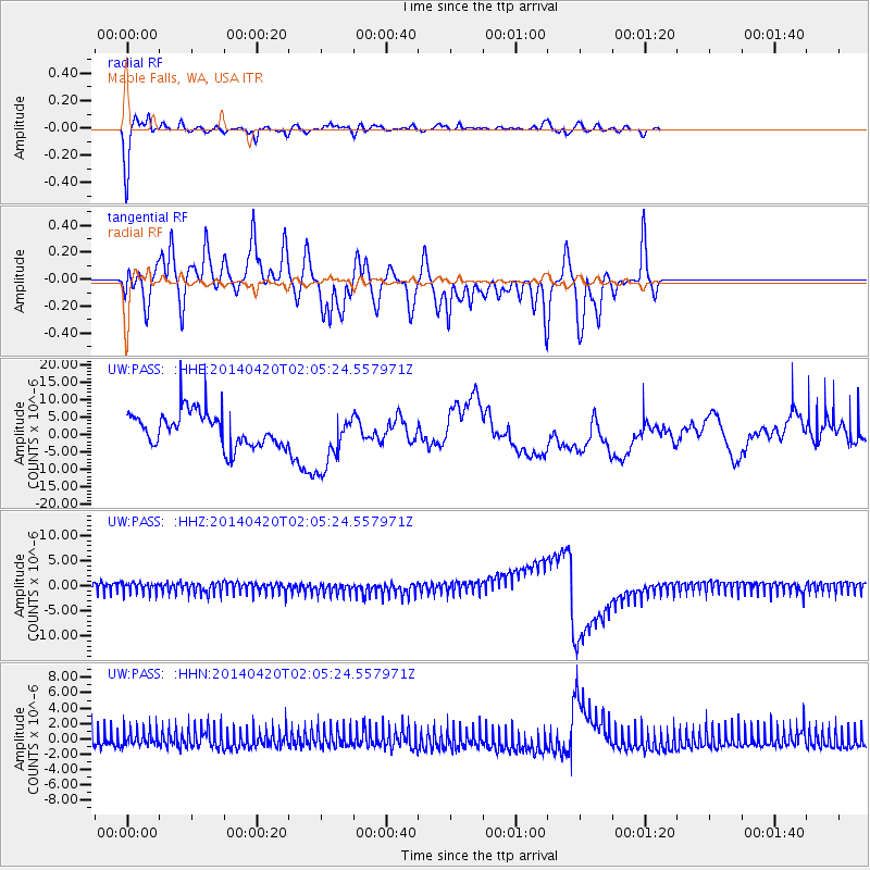
PASS Maple Falls, WA, USA - Earthquake Result Viewer
*The percent match for this event was below the threshold and hence no stack was calculated.
| Earthquake location: |
Southern East Pacific Rise |
| Earthquake latitude/longitude: |
-26.6/-115.0 |
| Earthquake time(UTC): |
2014/04/20 (110) 01:54:11 GMT |
| Earthquake Depth: |
10 km |
| Earthquake Magnitude: |
5.9 MWC, 5.9 MWC |
| Earthquake Catalog/Contributor: |
NEIC PDE/NEIC COMCAT |
|
| Network: |
UW Pacific Northwest Regional Seismic Network |
| Station: |
PASS Maple Falls, WA, USA |
| Lat/Lon: |
49.00 N/122.09 W |
| Elevation: |
174 m |
|
| Distance: |
75.5 deg |
| Az: |
355.201 deg |
| Baz: |
173.467 deg |
| Ray Param: |
$rayparam |
*The percent match for this event was below the threshold and hence was not used in the summary stack. |
|
| Radial Match: |
78.965965 % |
| Radial Bump: |
309 |
| Transverse Match: |
44.020763 % |
| Transverse Bump: |
313 |
| SOD ConfigId: |
626651 |
| Insert Time: |
2014-05-22 00:38:18.856 +0000 |
| GWidth: |
2.5 |
| Max Bumps: |
400 |
| Tol: |
0.001 |
|
Signal To Noise
| Channel | StoN | STA | LTA |
| UW:PASS: :HHZ:20140420T02:05:24.557971Z | 0.95321906 | 1.2411009E-6 | 1.3020102E-6 |
| UW:PASS: :HHN:20140420T02:05:24.557971Z | 1.0166274 | 1.1471308E-6 | 1.1283689E-6 |
| UW:PASS: :HHE:20140420T02:05:24.557971Z | 1.7326702 | 8.307248E-6 | 4.7944773E-6 |
| Arrivals |
| Ps | |
| PpPs | |
| PsPs/PpSs | |


