You are here: Home > Network List > AK - Alaska Regional Network Stations List
> Station KNK Knik Glacier, AK, USA > Earthquake Result Viewer
KNK Knik Glacier, AK, USA - Earthquake Result Viewer
| Earthquake location: |
Guerrero, Mexico |
| Earthquake latitude/longitude: |
17.4/-100.7 |
| Earthquake time(UTC): |
2014/05/08 (128) 17:00:17 GMT |
| Earthquake Depth: |
24 km |
| Earthquake Magnitude: |
6.4 MWW, 6.8 MI |
| Earthquake Catalog/Contributor: |
NEIC PDE/NEIC COMCAT |
|
| Network: |
AK Alaska Regional Network |
| Station: |
KNK Knik Glacier, AK, USA |
| Lat/Lon: |
61.41 N/148.46 W |
| Elevation: |
601 m |
|
| Distance: |
55.3 deg |
| Az: |
334.327 deg |
| Baz: |
120.671 deg |
| Ray Param: |
0.06482972 |
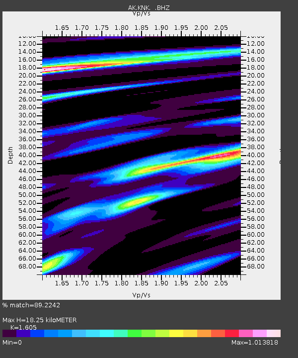
| Estimated Moho Depth: |
18.25 km |
| Estimated Crust Vp/Vs: |
1.61 |
| Assumed Crust Vp: |
6.566 km/s |
| Estimated Crust Vs: |
4.091 km/s |
| Estimated Crust Poisson's Ratio: |
0.18 |
|
| Radial Match: |
89.2242 % |
| Radial Bump: |
374 |
| Transverse Match: |
76.47838 % |
| Transverse Bump: |
400 |
| SOD ConfigId: |
626651 |
| Insert Time: |
2014-05-22 17:11:48.150 +0000 |
| GWidth: |
2.5 |
| Max Bumps: |
400 |
| Tol: |
0.001 |
|

Signal To Noise
| Channel | StoN | STA | LTA |
| AK:KNK: :BHZ:20140508T17:09:18.007986Z | 41.72788 | 4.847287E-6 | 1.1616423E-7 |
| AK:KNK: :BHN:20140508T17:09:18.007986Z | 15.169323 | 1.5053485E-6 | 9.923636E-8 |
| AK:KNK: :BHE:20140508T17:09:18.007986Z | 12.017499 | 1.5761149E-6 | 1.3115165E-7 |
| Arrivals |
| Ps | 1.8 SECOND |
| PpPs | 6.8 SECOND |
| PsPs/PpSs | 8.6 SECOND |


