You are here: Home > Network List > II - Global Seismograph Network (GSN - IRIS/IDA) Stations List
> Station PFO Pinon Flat, California, USA > Earthquake Result Viewer
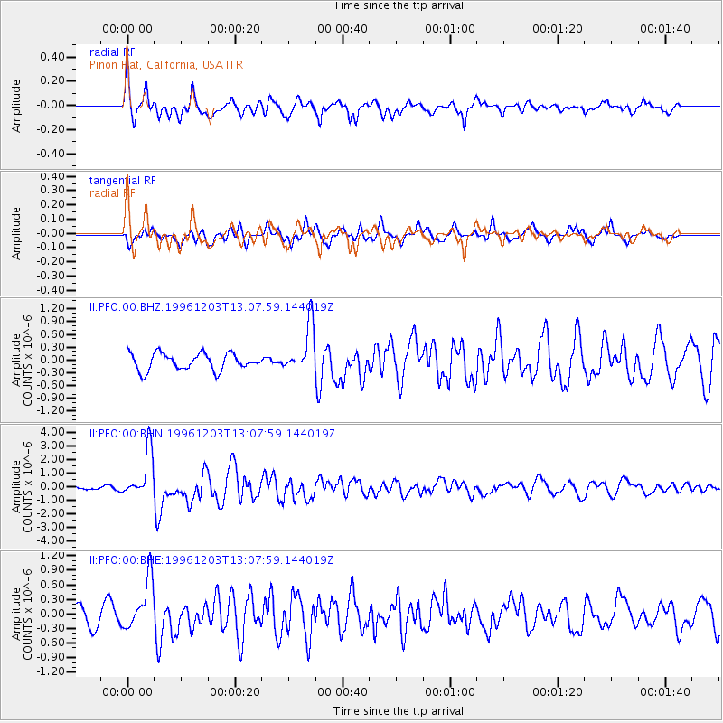
PFO Pinon Flat, California, USA - Earthquake Result Viewer
*The percent match for this event was below the threshold and hence no stack was calculated.
| Earthquake location: |
Tonga Islands Region |
| Earthquake latitude/longitude: |
-18.4/-172.3 |
| Earthquake time(UTC): |
1996/12/03 (338) 12:56:56 GMT |
| Earthquake Depth: |
33 km |
| Earthquake Magnitude: |
6.0 MB, 6.0 MS, 6.1 UNKNOWN, 6.1 MW |
| Earthquake Catalog/Contributor: |
WHDF/NEIC |
|
| Network: |
II Global Seismograph Network (GSN - IRIS/IDA) |
| Station: |
PFO Pinon Flat, California, USA |
| Lat/Lon: |
33.61 N/116.46 W |
| Elevation: |
1280 m |
|
| Distance: |
74.2 deg |
| Az: |
45.859 deg |
| Baz: |
234.758 deg |
| Ray Param: |
$rayparam |
*The percent match for this event was below the threshold and hence was not used in the summary stack. |
|
| Radial Match: |
79.23526 % |
| Radial Bump: |
400 |
| Transverse Match: |
66.58451 % |
| Transverse Bump: |
400 |
| SOD ConfigId: |
4480 |
| Insert Time: |
2010-03-01 21:51:12.772 +0000 |
| GWidth: |
2.5 |
| Max Bumps: |
400 |
| Tol: |
0.001 |
|
Signal To Noise
| Channel | StoN | STA | LTA |
| II:PFO:00:BHN:19961203T13:07:59.144019Z | 6.4873753 | 1.7555377E-6 | 2.706083E-7 |
| II:PFO:00:BHE:19961203T13:07:59.144019Z | 3.222451 | 5.269525E-7 | 1.6352537E-7 |
| II:PFO:00:BHZ:19961203T13:07:59.144019Z | 2.9256 | 5.6925484E-7 | 1.9457711E-7 |
| Arrivals |
| Ps | |
| PpPs | |
| PsPs/PpSs | |


