You are here: Home > Network List > AK - Alaska Regional Network Stations List
> Station WAX Waxell Ridge, AK, USA > Earthquake Result Viewer
WAX Waxell Ridge, AK, USA - Earthquake Result Viewer
| Earthquake location: |
Guerrero, Mexico |
| Earthquake latitude/longitude: |
17.4/-100.7 |
| Earthquake time(UTC): |
2014/05/08 (128) 17:00:17 GMT |
| Earthquake Depth: |
24 km |
| Earthquake Magnitude: |
6.4 MWW, 6.8 MI |
| Earthquake Catalog/Contributor: |
NEIC PDE/NEIC COMCAT |
|
| Network: |
AK Alaska Regional Network |
| Station: |
WAX Waxell Ridge, AK, USA |
| Lat/Lon: |
60.45 N/142.85 W |
| Elevation: |
1003 m |
|
| Distance: |
52.5 deg |
| Az: |
335.19 deg |
| Baz: |
126.072 deg |
| Ray Param: |
0.066676915 |
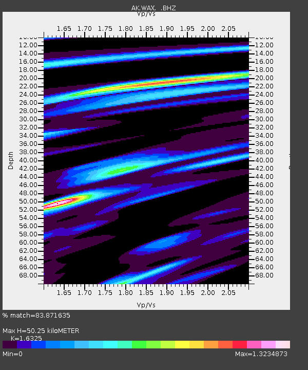
| Estimated Moho Depth: |
50.25 km |
| Estimated Crust Vp/Vs: |
1.63 |
| Assumed Crust Vp: |
6.566 km/s |
| Estimated Crust Vs: |
4.022 km/s |
| Estimated Crust Poisson's Ratio: |
0.20 |
|
| Radial Match: |
83.871635 % |
| Radial Bump: |
376 |
| Transverse Match: |
83.497856 % |
| Transverse Bump: |
400 |
| SOD ConfigId: |
626651 |
| Insert Time: |
2014-05-22 17:14:17.757 +0000 |
| GWidth: |
2.5 |
| Max Bumps: |
400 |
| Tol: |
0.001 |
|

Signal To Noise
| Channel | StoN | STA | LTA |
| AK:WAX: :BHZ:20140508T17:08:57.488027Z | 34.584995 | 5.84501E-6 | 1.6900421E-7 |
| AK:WAX: :BHN:20140508T17:08:57.488027Z | 7.4327073 | 1.6517115E-6 | 2.2222206E-7 |
| AK:WAX: :BHE:20140508T17:08:57.488027Z | 11.14081 | 2.2244644E-6 | 1.9966812E-7 |
| Arrivals |
| Ps | 5.2 SECOND |
| PpPs | 19 SECOND |
| PsPs/PpSs | 24 SECOND |


