You are here: Home > Network List > CC - Cascade Chain Volcano Monitoring Stations List
> Station JRO Johnston Ridge Observatory > Earthquake Result Viewer
JRO Johnston Ridge Observatory - Earthquake Result Viewer
| Earthquake location: |
Guerrero, Mexico |
| Earthquake latitude/longitude: |
17.4/-100.7 |
| Earthquake time(UTC): |
2014/05/08 (128) 17:00:17 GMT |
| Earthquake Depth: |
24 km |
| Earthquake Magnitude: |
6.4 MWW, 6.8 MI |
| Earthquake Catalog/Contributor: |
NEIC PDE/NEIC COMCAT |
|
| Network: |
CC Cascade Chain Volcano Monitoring |
| Station: |
JRO Johnston Ridge Observatory |
| Lat/Lon: |
46.28 N/122.22 W |
| Elevation: |
1280 m |
|
| Distance: |
33.9 deg |
| Az: |
332.814 deg |
| Baz: |
141.025 deg |
| Ray Param: |
0.07795839 |
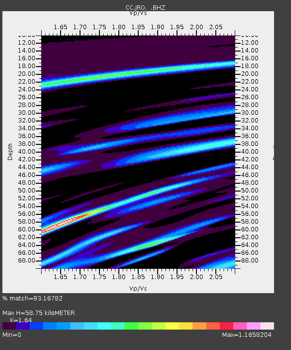
| Estimated Moho Depth: |
58.75 km |
| Estimated Crust Vp/Vs: |
1.64 |
| Assumed Crust Vp: |
6.566 km/s |
| Estimated Crust Vs: |
4.004 km/s |
| Estimated Crust Poisson's Ratio: |
0.20 |
|
| Radial Match: |
93.16782 % |
| Radial Bump: |
400 |
| Transverse Match: |
84.88304 % |
| Transverse Bump: |
400 |
| SOD ConfigId: |
626651 |
| Insert Time: |
2014-05-22 17:16:48.545 +0000 |
| GWidth: |
2.5 |
| Max Bumps: |
400 |
| Tol: |
0.001 |
|

Signal To Noise
| Channel | StoN | STA | LTA |
| CC:JRO: :BHZ:20140508T17:06:27.680013Z | 60.09437 | 6.055395E-6 | 1.0076476E-7 |
| CC:JRO: :BHN:20140508T17:06:27.680013Z | 15.597339 | 2.6427417E-6 | 1.6943541E-7 |
| CC:JRO: :BHE:20140508T17:06:27.680013Z | 38.114773 | 3.1492884E-6 | 8.262645E-8 |
| Arrivals |
| Ps | 6.3 SECOND |
| PpPs | 22 SECOND |
| PsPs/PpSs | 28 SECOND |


