You are here: Home > Network List > II - Global Seismograph Network (GSN - IRIS/IDA) Stations List
> Station PFO Pinon Flat, California, USA > Earthquake Result Viewer
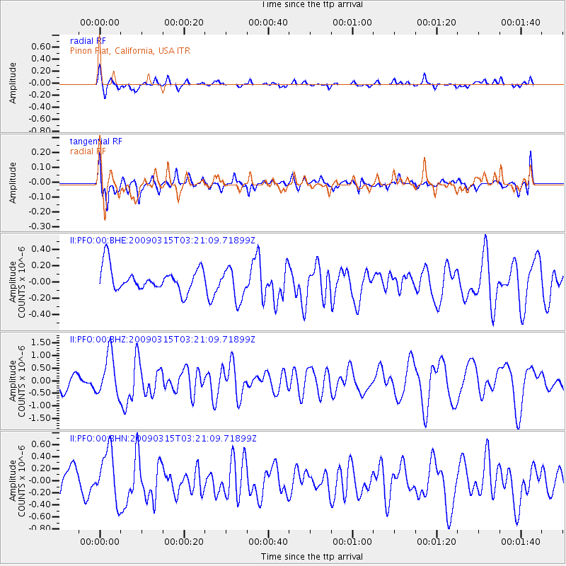
PFO Pinon Flat, California, USA - Earthquake Result Viewer
*The percent match for this event was below the threshold and hence no stack was calculated.
| Earthquake location: |
Galapagos Islands Region |
| Earthquake latitude/longitude: |
2.4/-95.1 |
| Earthquake time(UTC): |
2009/03/15 (074) 03:14:31 GMT |
| Earthquake Depth: |
10 km |
| Earthquake Magnitude: |
5.5 MS, 5.4 MB, 5.8 MW, 5.8 MW |
| Earthquake Catalog/Contributor: |
WHDF/NEIC |
|
| Network: |
II Global Seismograph Network (GSN - IRIS/IDA) |
| Station: |
PFO Pinon Flat, California, USA |
| Lat/Lon: |
33.61 N/116.46 W |
| Elevation: |
1280 m |
|
| Distance: |
36.9 deg |
| Az: |
329.616 deg |
| Baz: |
142.732 deg |
| Ray Param: |
$rayparam |
*The percent match for this event was below the threshold and hence was not used in the summary stack. |
|
| Radial Match: |
68.68956 % |
| Radial Bump: |
400 |
| Transverse Match: |
69.20065 % |
| Transverse Bump: |
400 |
| SOD ConfigId: |
2658 |
| Insert Time: |
2010-03-01 21:51:28.963 +0000 |
| GWidth: |
2.5 |
| Max Bumps: |
400 |
| Tol: |
0.001 |
|
Signal To Noise
| Channel | StoN | STA | LTA |
| II:PFO:00:BHZ:20090315T03:21:09.71899Z | 2.2428336 | 8.448389E-7 | 3.7668372E-7 |
| II:PFO:00:BHN:20090315T03:21:09.71899Z | 1.5421056 | 4.3106843E-7 | 2.7953237E-7 |
| II:PFO:00:BHE:20090315T03:21:09.71899Z | 1.4345955 | 2.0358749E-7 | 1.4191282E-7 |
| Arrivals |
| Ps | |
| PpPs | |
| PsPs/PpSs | |


