You are here: Home > Network List > CN - Canadian National Seismograph Network Stations List
> Station KILO KIRKLAND LAKE, ON > Earthquake Result Viewer
KILO KIRKLAND LAKE, ON - Earthquake Result Viewer
| Earthquake location: |
Guerrero, Mexico |
| Earthquake latitude/longitude: |
17.4/-100.7 |
| Earthquake time(UTC): |
2014/05/08 (128) 17:00:17 GMT |
| Earthquake Depth: |
24 km |
| Earthquake Magnitude: |
6.4 MWW, 6.8 MI |
| Earthquake Catalog/Contributor: |
NEIC PDE/NEIC COMCAT |
|
| Network: |
CN Canadian National Seismograph Network |
| Station: |
KILO KIRKLAND LAKE, ON |
| Lat/Lon: |
48.50 N/79.72 W |
| Elevation: |
314 m |
|
| Distance: |
35.4 deg |
| Az: |
24.21 deg |
| Baz: |
216.066 deg |
| Ray Param: |
0.077199824 |
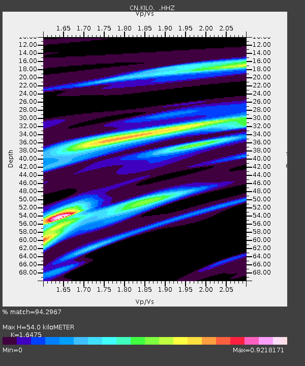
| Estimated Moho Depth: |
54.0 km |
| Estimated Crust Vp/Vs: |
1.65 |
| Assumed Crust Vp: |
6.61 km/s |
| Estimated Crust Vs: |
4.012 km/s |
| Estimated Crust Poisson's Ratio: |
0.21 |
|
| Radial Match: |
94.2967 % |
| Radial Bump: |
168 |
| Transverse Match: |
57.992264 % |
| Transverse Bump: |
400 |
| SOD ConfigId: |
626651 |
| Insert Time: |
2014-05-22 17:19:05.371 +0000 |
| GWidth: |
2.5 |
| Max Bumps: |
400 |
| Tol: |
0.001 |
|

Signal To Noise
| Channel | StoN | STA | LTA |
| CN:KILO: :HHZ:20140508T17:06:40.629995Z | 63.242798 | 2.832174E-6 | 4.4782553E-8 |
| CN:KILO: :HHN:20140508T17:06:40.629995Z | 24.225945 | 1.4983964E-6 | 6.18509E-8 |
| CN:KILO: :HHE:20140508T17:06:40.629995Z | 6.485321 | 1.0440698E-6 | 1.6098969E-7 |
| Arrivals |
| Ps | 5.8 SECOND |
| PpPs | 20 SECOND |
| PsPs/PpSs | 26 SECOND |


