You are here: Home > Network List > CI - Caltech Regional Seismic Network Stations List
> Station VCS Vincent Substation, Palmdale, CA, USA > Earthquake Result Viewer
VCS Vincent Substation, Palmdale, CA, USA - Earthquake Result Viewer
| Earthquake location: |
New Britain Region, P.N.G. |
| Earthquake latitude/longitude: |
-5.4/152.0 |
| Earthquake time(UTC): |
2000/11/17 (322) 21:45:51 GMT |
| Earthquake Depth: |
33 km |
| Earthquake Magnitude: |
5.7 MB |
| Earthquake Catalog/Contributor: |
WHDF/NEIC |
|
| Network: |
CI Caltech Regional Seismic Network |
| Station: |
VCS Vincent Substation, Palmdale, CA, USA |
| Lat/Lon: |
34.48 N/118.12 W |
| Elevation: |
991 m |
|
| Distance: |
92.9 deg |
| Az: |
55.805 deg |
| Baz: |
265.468 deg |
| Ray Param: |
0.041351527 |
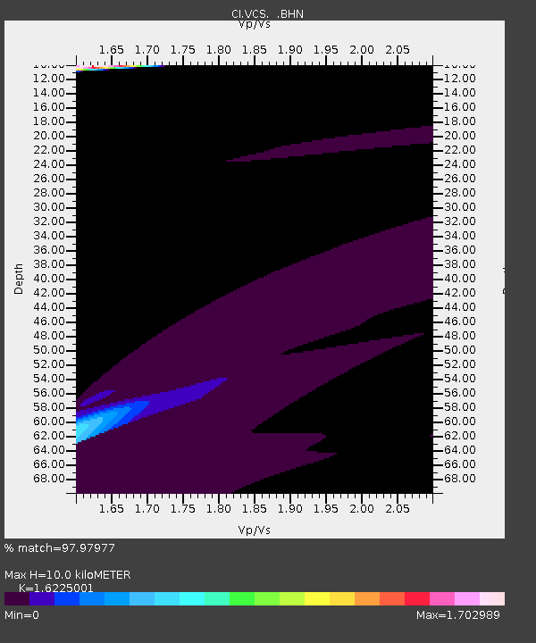
| Estimated Moho Depth: |
10.0 km |
| Estimated Crust Vp/Vs: |
1.62 |
| Assumed Crust Vp: |
6.1 km/s |
| Estimated Crust Vs: |
3.76 km/s |
| Estimated Crust Poisson's Ratio: |
0.19 |
|
| Radial Match: |
97.97977 % |
| Radial Bump: |
381 |
| Transverse Match: |
88.07011 % |
| Transverse Bump: |
311 |
| SOD ConfigId: |
3770 |
| Insert Time: |
2010-02-25 21:03:47.808 +0000 |
| GWidth: |
2.5 |
| Max Bumps: |
400 |
| Tol: |
0.001 |
|
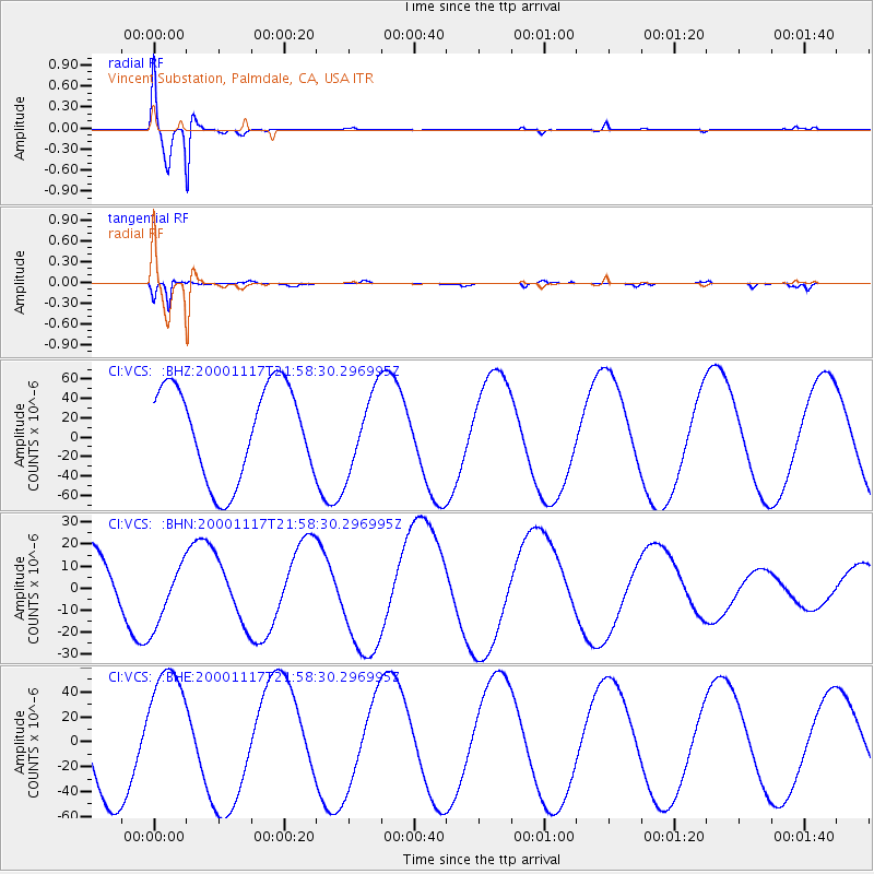
Signal To Noise
| Channel | StoN | STA | LTA |
| CI:VCS: :BHN:20001117T21:58:30.296995Z | 0.92893296 | 1.51716295E-5 | 1.6332318E-5 |
| CI:VCS: :BHE:20001117T21:58:30.296995Z | 1.212329 | 5.1779378E-5 | 4.2710664E-5 |
| CI:VCS: :BHZ:20001117T21:58:30.296995Z | 0.831912 | 3.9887367E-5 | 4.794662E-5 |
| Arrivals |
| Ps | 1.0 SECOND |
| PpPs | 4.2 SECOND |
| PsPs/PpSs | 5.3 SECOND |


