You are here: Home > Network List > II - Global Seismograph Network (GSN - IRIS/IDA) Stations List
> Station PFO Pinon Flat, California, USA > Earthquake Result Viewer
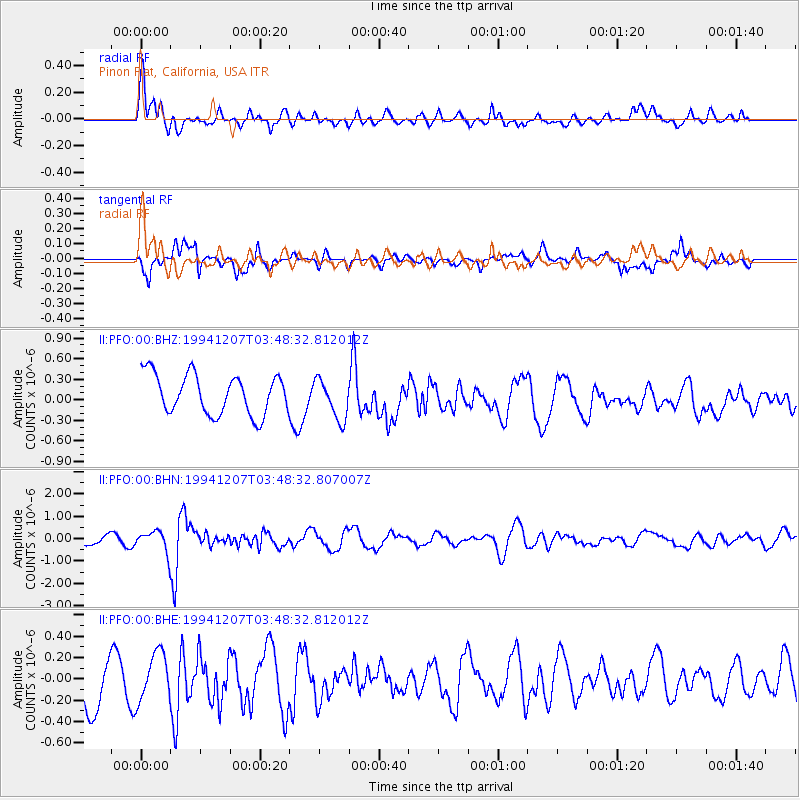
PFO Pinon Flat, California, USA - Earthquake Result Viewer
*The percent match for this event was below the threshold and hence no stack was calculated.
| Earthquake location: |
Jujuy Province, Argentina |
| Earthquake latitude/longitude: |
-23.5/-66.7 |
| Earthquake time(UTC): |
1994/12/07 (341) 03:37:55 GMT |
| Earthquake Depth: |
243 km |
| Earthquake Magnitude: |
5.6 MB, 5.8 UNKNOWN, 6.0 MW |
| Earthquake Catalog/Contributor: |
WHDF/NEIC |
|
| Network: |
II Global Seismograph Network (GSN - IRIS/IDA) |
| Station: |
PFO Pinon Flat, California, USA |
| Lat/Lon: |
33.61 N/116.46 W |
| Elevation: |
1280 m |
|
| Distance: |
73.9 deg |
| Az: |
318.496 deg |
| Baz: |
133.181 deg |
| Ray Param: |
$rayparam |
*The percent match for this event was below the threshold and hence was not used in the summary stack. |
|
| Radial Match: |
67.37877 % |
| Radial Bump: |
400 |
| Transverse Match: |
65.65836 % |
| Transverse Bump: |
400 |
| SOD ConfigId: |
4480 |
| Insert Time: |
2010-03-01 21:51:43.097 +0000 |
| GWidth: |
2.5 |
| Max Bumps: |
400 |
| Tol: |
0.001 |
|
Signal To Noise
| Channel | StoN | STA | LTA |
| II:PFO:00:BHN:19941207T03:48:32.807007Z | 1.9482522 | 4.6802285E-7 | 2.4022705E-7 |
| II:PFO:00:BHE:19941207T03:48:32.812012Z | 1.1116242 | 2.2351689E-7 | 2.0107235E-7 |
| II:PFO:00:BHZ:19941207T03:48:32.812012Z | 1.0173347 | 2.941749E-7 | 2.8916236E-7 |
| Arrivals |
| Ps | |
| PpPs | |
| PsPs/PpSs | |


