You are here: Home > Network List > TA - USArray Transportable Network (new EarthScope stations) Stations List
> Station I04A Tendick Farm, Oakridge, OR, USA > Earthquake Result Viewer
I04A Tendick Farm, Oakridge, OR, USA - Earthquake Result Viewer
| Earthquake location: |
Off East Coast Of Honshu, Japan |
| Earthquake latitude/longitude: |
39.8/143.6 |
| Earthquake time(UTC): |
2015/02/20 (051) 04:25:24 GMT |
| Earthquake Depth: |
14 km |
| Earthquake Magnitude: |
6.3 MWP |
| Earthquake Catalog/Contributor: |
NEIC PDE/NEIC COMCAT |
|
| Network: |
TA USArray Transportable Network (new EarthScope stations) |
| Station: |
I04A Tendick Farm, Oakridge, OR, USA |
| Lat/Lon: |
43.79 N/122.41 W |
| Elevation: |
731 m |
|
| Distance: |
66.4 deg |
| Az: |
52.051 deg |
| Baz: |
303.034 deg |
| Ray Param: |
0.05766269 |
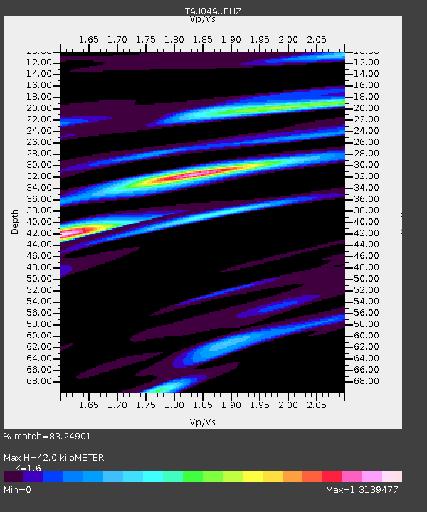
| Estimated Moho Depth: |
42.0 km |
| Estimated Crust Vp/Vs: |
1.60 |
| Assumed Crust Vp: |
6.522 km/s |
| Estimated Crust Vs: |
4.076 km/s |
| Estimated Crust Poisson's Ratio: |
0.18 |
|
| Radial Match: |
83.24901 % |
| Radial Bump: |
400 |
| Transverse Match: |
62.01974 % |
| Transverse Bump: |
400 |
| SOD ConfigId: |
7019011 |
| Insert Time: |
2019-04-16 23:28:36.766 +0000 |
| GWidth: |
2.5 |
| Max Bumps: |
400 |
| Tol: |
0.001 |
|

Signal To Noise
| Channel | StoN | STA | LTA |
| TA:I04A: :BHZ:20150220T04:35:40.849978Z | 2.8044076 | 4.4493888E-7 | 1.58657E-7 |
| TA:I04A: :BHN:20150220T04:35:40.849978Z | 1.1079794 | 1.6721432E-7 | 1.5091825E-7 |
| TA:I04A: :BHE:20150220T04:35:40.849978Z | 0.81682014 | 2.0248146E-7 | 2.4788991E-7 |
| Arrivals |
| Ps | 4.0 SECOND |
| PpPs | 16 SECOND |
| PsPs/PpSs | 20 SECOND |


