You are here: Home > Network List > TA - USArray Transportable Network (new EarthScope stations) Stations List
> Station N02D Trinity Center, CA, USA > Earthquake Result Viewer
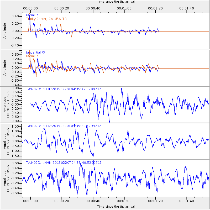
N02D Trinity Center, CA, USA - Earthquake Result Viewer
*The percent match for this event was below the threshold and hence no stack was calculated.
| Earthquake location: |
Off East Coast Of Honshu, Japan |
| Earthquake latitude/longitude: |
39.8/143.6 |
| Earthquake time(UTC): |
2015/02/20 (051) 04:25:24 GMT |
| Earthquake Depth: |
14 km |
| Earthquake Magnitude: |
6.3 MWP |
| Earthquake Catalog/Contributor: |
NEIC PDE/NEIC COMCAT |
|
| Network: |
TA USArray Transportable Network (new EarthScope stations) |
| Station: |
N02D Trinity Center, CA, USA |
| Lat/Lon: |
40.97 N/122.71 W |
| Elevation: |
937 m |
|
| Distance: |
67.7 deg |
| Az: |
54.735 deg |
| Baz: |
303.884 deg |
| Ray Param: |
$rayparam |
*The percent match for this event was below the threshold and hence was not used in the summary stack. |
|
| Radial Match: |
78.15932 % |
| Radial Bump: |
400 |
| Transverse Match: |
56.15805 % |
| Transverse Bump: |
400 |
| SOD ConfigId: |
7019011 |
| Insert Time: |
2019-04-16 23:28:52.380 +0000 |
| GWidth: |
2.5 |
| Max Bumps: |
400 |
| Tol: |
0.001 |
|
Signal To Noise
| Channel | StoN | STA | LTA |
| TA:N02D: :HHZ:20150220T04:35:49.529971Z | 3.2692857 | 3.8178112E-7 | 1.1677815E-7 |
| TA:N02D: :HHN:20150220T04:35:49.529971Z | 1.3145043 | 1.4352932E-7 | 1.0918894E-7 |
| TA:N02D: :HHE:20150220T04:35:49.529971Z | 1.1394242 | 1.8697256E-7 | 1.640939E-7 |
| Arrivals |
| Ps | |
| PpPs | |
| PsPs/PpSs | |


