You are here: Home > Network List > IM - International Miscellaneous Stations Stations List
> Station IL31 ILAR Array, Eilson, AK, USA > Earthquake Result Viewer
IL31 ILAR Array, Eilson, AK, USA - Earthquake Result Viewer
| Earthquake location: |
Guerrero, Mexico |
| Earthquake latitude/longitude: |
17.4/-100.7 |
| Earthquake time(UTC): |
2014/05/08 (128) 17:00:17 GMT |
| Earthquake Depth: |
24 km |
| Earthquake Magnitude: |
6.4 MWW, 6.8 MI |
| Earthquake Catalog/Contributor: |
NEIC PDE/NEIC COMCAT |
|
| Network: |
IM International Miscellaneous Stations |
| Station: |
IL31 ILAR Array, Eilson, AK, USA |
| Lat/Lon: |
64.77 N/146.89 W |
| Elevation: |
419 m |
|
| Distance: |
56.5 deg |
| Az: |
338.224 deg |
| Baz: |
124.253 deg |
| Ray Param: |
0.06404338 |
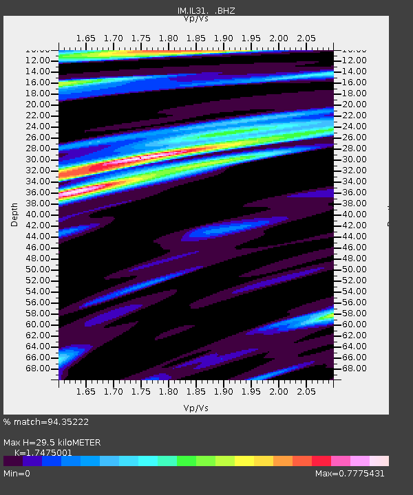
| Estimated Moho Depth: |
29.5 km |
| Estimated Crust Vp/Vs: |
1.75 |
| Assumed Crust Vp: |
6.566 km/s |
| Estimated Crust Vs: |
3.757 km/s |
| Estimated Crust Poisson's Ratio: |
0.26 |
|
| Radial Match: |
94.35222 % |
| Radial Bump: |
400 |
| Transverse Match: |
87.29984 % |
| Transverse Bump: |
400 |
| SOD ConfigId: |
626651 |
| Insert Time: |
2014-05-22 17:25:55.701 +0000 |
| GWidth: |
2.5 |
| Max Bumps: |
400 |
| Tol: |
0.001 |
|

Signal To Noise
| Channel | StoN | STA | LTA |
| IM:IL31: :BHZ:20140508T17:09:26.648977Z | 94.11623 | 2.3845507E-7 | 2.5336235E-9 |
| IM:IL31: :BHN:20140508T17:09:26.648977Z | 69.983696 | 8.52738E-8 | 1.2184808E-9 |
| IM:IL31: :BHE:20140508T17:09:26.648977Z | 22.638933 | 6.8153255E-8 | 3.0104446E-9 |
| Arrivals |
| Ps | 3.5 SECOND |
| PpPs | 12 SECOND |
| PsPs/PpSs | 15 SECOND |


