You are here: Home > Network List > TM - Thai Seismic Monitoring Network Stations List
> Station UBPT UBPT Phase1 > Earthquake Result Viewer
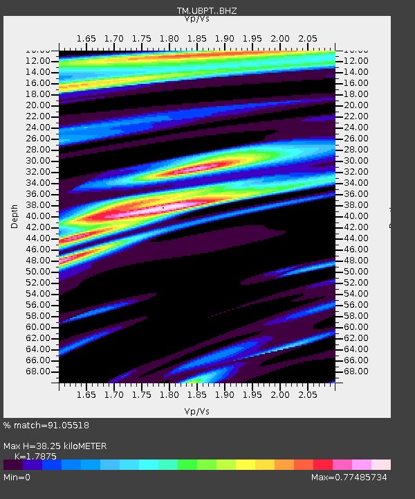
UBPT UBPT Phase1 - Earthquake Result Viewer
| Earthquake location: |
Off East Coast Of Honshu, Japan |
| Earthquake latitude/longitude: |
39.8/143.6 |
| Earthquake time(UTC): |
2015/02/20 (051) 04:25:24 GMT |
| Earthquake Depth: |
14 km |
| Earthquake Magnitude: |
6.3 MWP |
| Earthquake Catalog/Contributor: |
NEIC PDE/NEIC COMCAT |
|
| Network: |
TM Thai Seismic Monitoring Network |
| Station: |
UBPT UBPT Phase1 |
| Lat/Lon: |
15.28 N/105.47 E |
| Elevation: |
120 m |
|
| Distance: |
41.3 deg |
| Az: |
244.572 deg |
| Baz: |
46.09 deg |
| Ray Param: |
0.07389947 |
| Estimated Moho Depth: |
38.25 km |
| Estimated Crust Vp/Vs: |
1.79 |
| Assumed Crust Vp: |
6.444 km/s |
| Estimated Crust Vs: |
3.605 km/s |
| Estimated Crust Poisson's Ratio: |
0.27 |
|
| Radial Match: |
91.05518 % |
| Radial Bump: |
400 |
| Transverse Match: |
75.147514 % |
| Transverse Bump: |
400 |
| SOD ConfigId: |
7019011 |
| Insert Time: |
2019-04-16 23:29:23.353 +0000 |
| GWidth: |
2.5 |
| Max Bumps: |
400 |
| Tol: |
0.001 |
|

Signal To Noise
| Channel | StoN | STA | LTA |
| TM:UBPT: :BHZ:20150220T04:32:37.760012Z | 12.794883 | 1.9429872E-6 | 1.5185658E-7 |
| TM:UBPT: :BHN:20150220T04:32:37.760012Z | 14.683195 | 1.1296912E-6 | 7.6937695E-8 |
| TM:UBPT: :BHE:20150220T04:32:37.760012Z | 3.940323 | 4.317784E-7 | 1.0957944E-7 |
| Arrivals |
| Ps | 5.0 SECOND |
| PpPs | 15 SECOND |
| PsPs/PpSs | 20 SECOND |


