You are here: Home > Network List > TO - Tectonic Observatory Stations List
> Station CC36 CCSE CC36 > Earthquake Result Viewer
CC36 CCSE CC36 - Earthquake Result Viewer
| Earthquake location: |
Off East Coast Of Honshu, Japan |
| Earthquake latitude/longitude: |
39.8/143.6 |
| Earthquake time(UTC): |
2015/02/20 (051) 04:25:24 GMT |
| Earthquake Depth: |
14 km |
| Earthquake Magnitude: |
6.3 MWP |
| Earthquake Catalog/Contributor: |
NEIC PDE/NEIC COMCAT |
|
| Network: |
TO Tectonic Observatory |
| Station: |
CC36 CCSE CC36 |
| Lat/Lon: |
36.39 N/118.96 W |
| Elevation: |
265 m |
|
| Distance: |
72.8 deg |
| Az: |
56.893 deg |
| Baz: |
306.946 deg |
| Ray Param: |
0.053436425 |
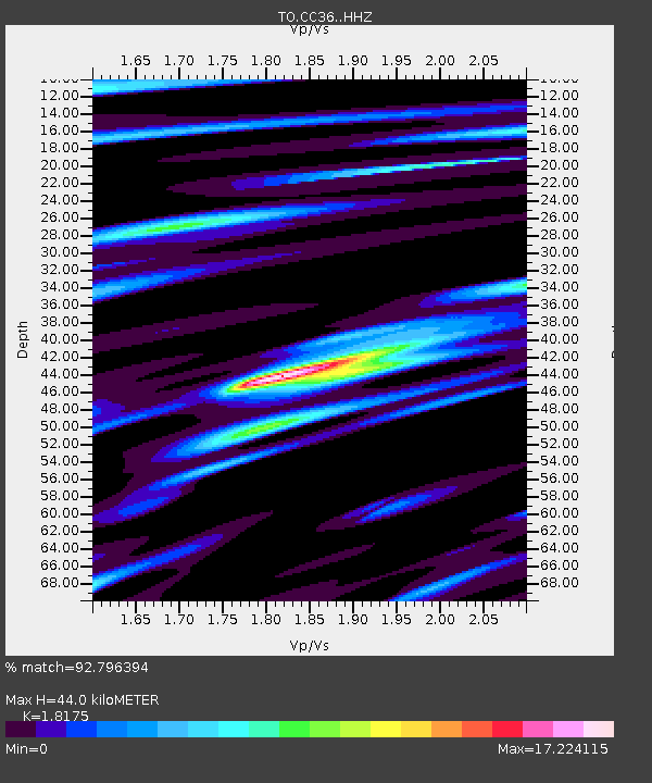
| Estimated Moho Depth: |
44.0 km |
| Estimated Crust Vp/Vs: |
1.82 |
| Assumed Crust Vp: |
6.291 km/s |
| Estimated Crust Vs: |
3.461 km/s |
| Estimated Crust Poisson's Ratio: |
0.28 |
|
| Radial Match: |
92.796394 % |
| Radial Bump: |
358 |
| Transverse Match: |
92.7964 % |
| Transverse Bump: |
358 |
| SOD ConfigId: |
7019011 |
| Insert Time: |
2019-04-16 23:29:34.672 +0000 |
| GWidth: |
2.5 |
| Max Bumps: |
400 |
| Tol: |
0.001 |
|

Signal To Noise
| Channel | StoN | STA | LTA |
| TO:CC36: :HHZ:20150220T04:36:20.310Z | 3.8689835 | 9.021078E-9 | 2.3316404E-9 |
| $trig.getChannelId() | $trig.getValue() | $trig.getSTA() | $trig.getLTA() |
| TO:CC36: :HHE:20150220T04:36:20.310Z | 1.8639107 | 1.6913555E-7 | 9.07423E-8 |
| Arrivals |
| Ps | 5.9 SECOND |
| PpPs | 19 SECOND |
| PsPs/PpSs | 25 SECOND |


