You are here: Home > Network List > UW - Pacific Northwest Regional Seismic Network Stations List
> Station MRBL Marblemount, WA, USA > Earthquake Result Viewer
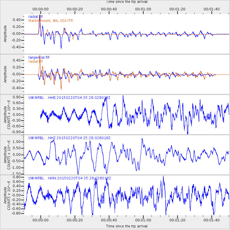
MRBL Marblemount, WA, USA - Earthquake Result Viewer
*The percent match for this event was below the threshold and hence no stack was calculated.
| Earthquake location: |
Off East Coast Of Honshu, Japan |
| Earthquake latitude/longitude: |
39.8/143.6 |
| Earthquake time(UTC): |
2015/02/20 (051) 04:25:24 GMT |
| Earthquake Depth: |
14 km |
| Earthquake Magnitude: |
6.3 MWP |
| Earthquake Catalog/Contributor: |
NEIC PDE/NEIC COMCAT |
|
| Network: |
UW Pacific Northwest Regional Seismic Network |
| Station: |
MRBL Marblemount, WA, USA |
| Lat/Lon: |
48.52 N/121.48 W |
| Elevation: |
75 m |
|
| Distance: |
64.4 deg |
| Az: |
47.281 deg |
| Baz: |
301.711 deg |
| Ray Param: |
$rayparam |
*The percent match for this event was below the threshold and hence was not used in the summary stack. |
|
| Radial Match: |
65.77421 % |
| Radial Bump: |
400 |
| Transverse Match: |
53.029995 % |
| Transverse Bump: |
400 |
| SOD ConfigId: |
7019011 |
| Insert Time: |
2019-04-16 23:30:03.586 +0000 |
| GWidth: |
2.5 |
| Max Bumps: |
400 |
| Tol: |
0.001 |
|
Signal To Noise
| Channel | StoN | STA | LTA |
| UW:MRBL: :HHZ:20150220T04:35:28.028018Z | 2.6932805 | 4.086163E-7 | 1.5171695E-7 |
| UW:MRBL: :HHN:20150220T04:35:28.028018Z | 0.72717535 | 1.7984853E-7 | 2.4732483E-7 |
| UW:MRBL: :HHE:20150220T04:35:28.028018Z | 1.8779562 | 2.9353288E-7 | 1.5630445E-7 |
| Arrivals |
| Ps | |
| PpPs | |
| PsPs/PpSs | |


